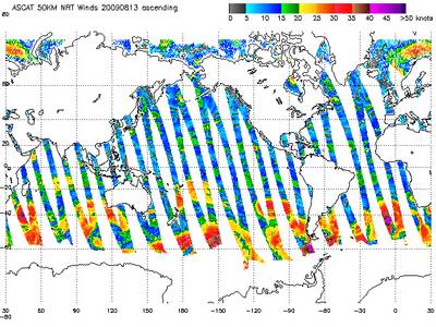
Advanced Scatterometer Instrument (ASCAT) global wind image from August 2009. This image is from one set of satellite passes on a single day.
NOAA/NESDIS.
Lorem ipsum dolor
Lorem ipsum dolor sit amet, consectetur adipiscing elit. Lorem ipsum dolor sit amet, consectetur adipiscing elit. Praesent eget mauris vitae purus aliquet pretium. Nullam nibh neque, consectetur vel, iaculis vitae, volutpat et, mi. Aliquam vel justo id purus facilisis ultricies. Nulla facilisi.