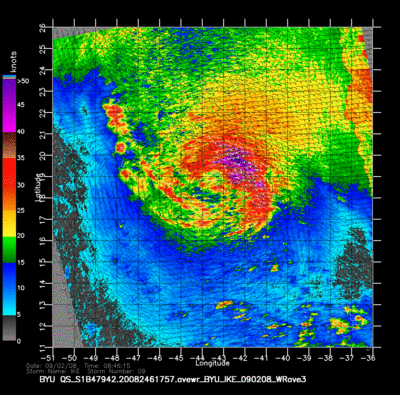
Hurricane Ike surface winds from the Quick Scatterometer (QuikSCAT) satellite in 2008. Colors represent intensity and arrows represent direction of the wind. Note that the wind scale tops out at 50knots (about 92 km/h or 57 mph). The QuikSCAT data is not reliable above 50knots.
NASA
Lorem ipsum dolor
Lorem ipsum dolor sit amet, consectetur adipiscing elit. Lorem ipsum dolor sit amet, consectetur adipiscing elit. Praesent eget mauris vitae purus aliquet pretium. Nullam nibh neque, consectetur vel, iaculis vitae, volutpat et, mi. Aliquam vel justo id purus facilisis ultricies. Nulla facilisi.