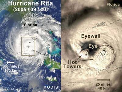
Follow this link to skip to the main content
Hurricanes: Science and Society
Gallery
Satellite view (MODIS) and detailed imagery of Hurricane Rita as she intensified on September 20, 2005. The area contained in the square on the left is depicted to the right. The cloud-free eye and surrounding eyewall are clearly visible. "Hot towers" are the towering high clouds in a hurricane's eyewall that can generate very heavy rainfall and reach the top of the troposphere. These towers are called "hot" because a large quantity of heat is released inside them by water vapor condensing to form rain.
Rita eye closeup
Satellite view (MODIS) and detailed imagery of Hurricane Rita as she intensified on September 20, 2005. The area contained in the square on the left is depicted to the right. The cloud-free eye and surrounding eyewall are clearly visible. "Hot towers" are the towering high clouds in a hurricane's eyewall that can generate very heavy rainfall and reach the top of the troposphere. These towers are called "hot" because a large quantity of heat is released inside them by water vapor condensing to form rain.
NASA