
Basic Statistics
Dates
Maximum wind speed Minimum pressure Deaths Damage Landfall
October 4- October 19, 1979
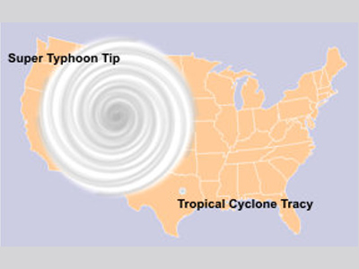
305 km/hr (190 mph) 870 mb 86 Unknown Japan In early October 1979, an active monsoon trough existed in the western Pacific Ocean extending from the Philippines to the Marshall Islands. From this, the largest and most intense tropical cyclone ever recorded, Typhoon Tip, emerged. The development of this typhoon was initially very slow. Tropical Storm Roger formed from the same monsoon trough southwest of Guam on October 3, 1979. The presence of this tropical storm prevented the development of another low pressure system (which would later become Typhoon Tip) to its southeast, near the Micronesian state of Pohnpei. However, the erratically moving low-pressure disturbance did gain enough strength to become designated as Tropical Depression 23 on 5 October. The tropical depression, still influenced by nearby Tropical Storm Roger, moved slowly and irregularly for several days while strengthening to become a tropical storm (Tropical Storm Tip). The storm was unable to intensify further, though, until Tropical Storm Roger tracked to the north, became entrained in the Westerlies, and turned extratropical on 8 October. After this, Tropical Storm Tip’s forward motion became more stable and the storm moved northwest towards Guam. Early on 9 October, Tropical Storm Tip turned to the west and developed into a typhoon. Very favorable conditions for strengthening, including outflow from extratropical Roger and the presence of a tropical upper-tropospheric trough, were in place at this time. This allowed Typhoon Tip to rapidly intensify. By 11 October, Tip was a super typhoon with winds of at least 241 km/h (150 mph). From 9- 11 October, the central pressure of the storm dropped 92 mbar and the typhoon’s circulation expanded to a diameter of 2220 km (1,380 mi) with gale-force winds extending 1086 km (675 mi) from its center. This set a world record for the largest tropical cyclone- at its largest, Tip was nearly half as large as the continental United States!
Super Typhoon Tip continued to strengthen over the open waters of the Western Pacific until reaching peak intensity on 12 October, about 837 km (520 mi) north-northwest of Guam. At this point, winds were 306 km/h (190 mph), the eye was 15 km (9.3 mi) wide and the central pressure was 870 mb (hPa), which is among world records for low pressures associated with tropical cyclones. Typhoon Tip weakened after peaking with winds of 233 km/h (145 mph). It maintained this intensity for several days as it continued moving in a west-northwest direction. The typhoon then weakened further, shrank in size, and then curved toward the northeast on 17 October. A greatly weakened Typhoon Tip made landfall on Honshu, the largest of the Japanese Islands, on 19 October with winds of 129 km/h (80 mph). The storm quickly moved over the island and rapidly deteriorated. It became extratropical over northern Honshu just hours after landfall and was last observed near the Aleutian Islands some time around 22 October. The typhoon produced enough rainfall to cause over 600 mudslides and much flooding in the mountains of Japan. Broken rivers resulted in 27 destroyed bridges as well as the destruction of 105 dikes. Over 22,000 homes were flooded and at least 11,000 people were left homeless. The rainfall caused a breach in a flood-retaining wall at Camp Fuji, a U.S. Marine Corps training facility near Gotemba, Japan. During the flooding, a fire broke out in the camp killing 13 marines and injuring 68 others. Eight ships were sunk or grounded, leaving 44 fishermen dead, and amongst the damaged ships was a Chinese freighter that broke in half. In total, 99 people died as a result of Typhoon Tip. Total economic losses in Japan due to the event are unknown, but there were at least several million dollars in damage to the agriculture and fishing industries. Fast Facts:
Sources:
Typhoon Tip. Wikipedia. 2009. Web. Emanuel, Kerry. DivineWind: The History and Science of Hurricanes. New York: Oxford University Press, 2005. Pp 267. Mooney, Chris. Storm World. Orlando: Harcourt, 2007. Pp 113. Iacovelli, Debi and Tim Vasquez. “Shattering All Records.” Mariners Weather Log 42.2. (1998). Pp 4-8. Web. Dunnavan, George M. “Super Typhoon Tip.” Annual Typhoon Report. Guam: Joint Typhoon Warning Center, 1979. Pp 72-77. Web. |
 |
Please address comments and questions to hurricane@etal.uri.edu