
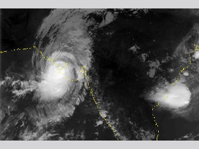
The deadliest cyclone of the 1998 North Indian Ocean season was first detected on 1 June as an area of low pressure in the Arabian Sea over India’s Laccadive Islands. The system organized into Depression ARB 02 early on 4 June, as determined by the India Meteorological Department. Later that day, the depression strengthened into a deep depression with winds up to 61 km/h (38 mph). It was upgraded into a cyclonic storm the next day, equivalent to a tropical storm on the Saffir-Simpson Hurricane Wind Scale. The small cyclone proceeded to move slowly westward. Strong wind shear caused the cyclone to weaken back to tropical depression strength. After making a turn for the northwest, where wind shear lessened, the depression was able to re-strengthen and reached severe cyclonic storm status by 6 June with winds of 101 km/h (63 mph). Soon after, the cyclone began a northward turn with an accompanied increase in forward speed.
Tropical Cyclone 03A continued to increase in intensity as it moved northward off the western coast of India. The cyclone passed about 552 km (345 mi) west of Bombay on 8 June, reaching an estimated peak intensity of 185 km/h (115 mph). Early on 9 June, the cyclone weakened slightly with 169 km/h (105 mph) winds, but this decline was short lived. Just before striking the Indian coastline, the cyclone intensified to have winds of 193 km/h (120 mph). It made landfall later that day in the Indian state of Gujarat near the city of Porbandar, about halfway between Mumbai, India and Karachi, Pakistan. The 4.9-meter (16-foot) storm surge accompanying the cyclone’s landfall caused great loss of life, mostly to coastal workers. It is estimated that 10,000 people were killed during the cyclone and over 15,000 were displaced. Communication was greatly hindered throughout the impacted region as power transmission towers fell from the cyclone’s high winds. Over 162,000 structures where either destroyed or otherwise damaged, helping to bring the total storm damages to almost $290 million (1998 USD). Fast Facts:
Sources:
“1998 Indian Ocean Cyclones.” NOAA National Geophysical Data Center. 26 Jul 2006. Web. “1998 North Indian Ocean cyclone season.” Wikipedia. 2010. Web. “1998 Annual Tropical Cyclone Report.” Joint Typhoon Warning Center. 1998. Pp 11-113. Web. Padgett, Gary. Monthly Tropical Cyclone Summary for June 1998. Typhoon 2000. 14 Jul. 1998. Web. “Tropical Cyclone Scales.” Wikipedia. 2010. Web. |
 |
Please address comments and questions to hurricane@etal.uri.edu