
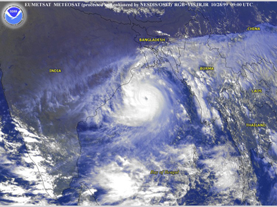
In the latter half of October 1999, a tropical disturbance formed in the South China Sea. As the system tracked westward, the Joint Typhoon Warning Center (JTWC) issued a Tropical Cyclone Formation Alert (TCFA) out of concern that the system could significantly develop. When it failed to do so, the alert was discontinued. Then, on 25 October, the system became organized and another TCFA was issued. It was determined shortly after that a tropical depression had formed over the Malay Peninsula, Malaysia. As Tropical Depression 05B tracked northwestward over the warm waters of the Bay of Bengal and in conditions of low wind shear, it became a tropical storm. On 27 October, the storm intensified into a cyclone. Continued strengthening occurred, and on 28 October, the cyclone was at peak intensity with winds of 257 km/h (160 mph) – a Category 5 hurricane on the Saffir-Simpson Hurricane Wind Scale. This intense of a cyclone is very rare in the northern Indian Ocean. In fact, this cyclone was the first to be given the label “super cyclonic storm” by the India Meteorological Department.
On 29 October, the cyclone made landfall near the city of Bhubaneswar, in the state of Orissa, India. Maximum sustained surface wind speeds at landfall were estimated at 260 km/h (162 mph), and the minimum central pressure was estimated to be 912 mb (hPa). After landfall, the cyclone was unable to move far inland due to the presence of a subtropical ridge to its north. The storm stalled about 48 km (30 mi) inland for over a day while it continued to slowly weaken. On 31 October, the now tropical storm, re-entered the Bay of Bengal. It soon after became a tropical depression and gradually weakened until it dissipated over the open waters of the Bay on 3 November. This cyclone caused great damage in India. Its re-curving track and relatively slow movement caused huge amounts of rainfall over the area, averaging around 600 mm (23.6 in) in 6 days. Much of the destruction, however, can be attributed to the 7.9 m (26 ft) storm surge that accompanied the cyclone’s landfall and traveled up to 20.1 km (12.5 mi) inland. About 1.67 million people were left homeless as 275,000 homes were destroyed. Some 1,535 km^2, (600 mi^2) of crops were destroyed and 90 million trees were ruined during the cyclone. Additionally, 2.5 million domesticated animals were killed with 406,000 of those being livestock. The human death toll is believed to be as high as 15,000, though only about 10,000 have been confirmed dead. The storm affected over 20 million people across 14 districts and caused $4.5 billion in damage (1999 USD). Fast Facts:
Sources:
“1999 Orissa Cyclone.” Wikipedia. 2010. Web. “Tropical Cyclone 05B.” United States Naval Observatory. Accessed 08 Feb. 2010. Web. Simon Francis. 2001. Performance of built environment in the October 1999 Orissa Syper Cyclone. |
 |
Please address comments and questions to hurricane@etal.uri.edu