
Hurricane Ike was a Cape Verde-type hurricane, beginning as a tropical disturbance near Africa at the end of August. On September 1, 2008, it became a tropical storm. During the overnight hours of 1 September, Ike stopped intensifying, as northerly wind shear began to impact the system. By late morning on 2 September, however, shear relaxed and Ike began to intensify again. By late morning on 3 September, Ike strengthened to just below hurricane status, and by mid-afternoon Ike was upgraded to a hurricane. Hurricane Ike then explosively intensified and was upgraded to a major hurricane with winds of 185 km/h (115 mph) only three hours after being upgraded to a hurricane. Ike continued to intensify and was further upgraded to a Category 4 hurricane on the Saffir-Simpson Hurricane Wind Scale three hours later with winds of 215 km/h (135 mph) and an estimated pressure of 948 mbar. It is important to note that these measurements were satellite estimates, as Ike was still too far from land for reconnaissance aircraft to reach.
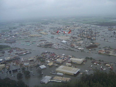
By the early morning hours on 4 September, Ike had reached its peak intensity of 230 km/h (145 mph) with an estimated pressure of 935 mbar, making it the most intense storm of the season. After a period of weakening and reintensification, Hurricane Ike made its first landfall on the Turks and Caicos Islands (in the southeastern Bahamas) on 7 September as a Category 4 storm, with 217 km/h (135 mph) winds. Power was lost throughout Grand Turk Island, and 95% of the houses were damaged. Niney-five percent of the houses were also damaged in South Caicos. Ike then weakened slightly to Category 3 status, with maximum sustained winds of 204 km/h (127 mph), before making another landfall on Great Inagua Island in the southeastern Bahamas later on 7 September. Approximately 70-80% of the houses on Great Inagua Island sustained roof damage, and 25% had major damage and/or were destroyed. After Hurricane Ike passed over the Turks and Caicos, it continued west at 24 km/h (15 mph), heading directly for eastern Cuba. Ike made 2 landfalls in Cuba, the first of which occurred near Cabo Lucrecia on the northern coast. Here, Ike came ashore as a strong Category 3 hurricane on the evening of 7 September. The hurricane traveled across the central provinces of Cuba, and then emerged south of the island on September 8. Ike then made a second landfall as a Category 1 hurricane in Pinar del Río before entering the Gulf of Mexcico in the afternoon of September 9 (Ike had weakened as it crossed the island). Across the country, powerful winds caused significant damage to many crops. Banana, coffee, yucca, and corn crops sustained serious damage. Roadways were also seriously impacted the island. In advance of the hurricane, about 2.6 million people were evacuated, or about 23% of the entire Cuban population. Due to this massive evacuations and other preparations, only seven direct deaths were reported due to the hurricane. Ike’s interaction with Cuba caused much of the hurricane’s inner core to become disrupted, and the wind field expanded as the hurricane moved into the Gulf of Mexico. Hurricane Ike was able to regain strength, though, and became a Category 2 storm over the warm waters of the open Gulf of Mexico. As Ike passed over the warm waters of the Loop Current during the night of 10 September, the storm exhibited a rapid drop in central pressure, falling from 963 mbar to 944 mbar. This drop was not reflected by wind speed, however, which only increased to 160 km/h (100 mph) from 140 km/h (85 mph). Over the next two days, Ike maintained a steady course towards Galveston and Houston, TX. Though the hurricane had only increased to a strong Category 2, it exhibited an unusually large wind field, which caused a projected storm surge of that which would usually accompany a Category 4 hurricane. It was due to this storm surge potential that a hurricane watch was issued from Cameron, LA, to Port Mansfield, TX, earlier than the usual 36-hr threshold (storm surge was expected to impact the area well before tropical-storm-force winds reached the coast). Hurricane Ike made its final landfall near Galveston, TX at 2:10am CDT on 13 September as a strong Category 2 hurricane (it had sustained winds of 110mph, just 1 mph shy of Category 3 status), with a Category 5 equivalent storm surge. Hurricane-force winds extended 120 miles (193 km) from the center. Ike’s 4.6 m (15-ft) storm surge caused a massive swath of damage, stretching from Galveston, Texas, east across all of coastal Louisiana. The surge covered hundreds of kilometers of the Gulf Coast because the hurricane was such a large storm. As the hurricane grew in size, its large wind field pushed water towards the coastline well before Ike’s eye made landfall. Higher-than-normal water levels affected virtually the entire U.S. Gulf Coast- in addition to impacting coastal Louisiana and Texas, Ike also caused flooding and significant damage along the Mississippi coastline and the Florida Panhandle. On 13 September, Hurricane Ike began a slow turn north, then northeast, and dissipated to a tropical storm near Palestine, TX. It became a tropical depression and continued northeast, passing near St. Louis, MO. Early on 14 September, Ike merged with a large cold front moving from west to east over the central U.S. and became extratropical. This deep low pressure continued toward the north-east spreading heavy rains across the Midwest. It moved into Canada that night, giving strong winds and heavy rain across Southern Ontario and most of Quebec, before exiting into the Atlantic at the latitude of the Labrador Sea, early on the 16 September. The worst devastation from Hurricane Ike occurred on the Bolivar Peninsula, TX, which was inundated with 3.7-4.9 m (12 -16 ft) of water. The storm surge exceeded the island’s elevation, leading to inundation, overwash and extreme coastal change. Complete tide gauge records for this area are unavailable since many of the sensors failed during the storm, although ground assessment teams determined that the surge was generally between 15 and 20 ft. The highest storm surge measured by any National Ocean Service (NOS) tide gauge was at Sabine Pass North, TX, where 3.9 m (12.79 ft) was recorded at early on 13 September, just as the hurricane was making landfall near Galveston, TX. The highest watermark, collected by the U.S. Federal Emergency Management Agency (FEMA), was located about 16 km (10 mi) inland in Chambers County and measured approximately 5 m (17.5 ft). Almost every structure on parts of the Bolivar Peninsula were completely flattened due to the surge and accompanying waves. Protected by a seawall, much of the city of Galveston was spared direct impact by storm surge and wave action from the Gulf of Mexico; however the city was still inundated by surge when water rose on the north side of the island from Galveston Bay. The city of Houston was largely spared, although high winds caused many of the windows on the city’s tallest buildings to blow out including that of the 75-story JP Morgan Chase Building. Also a result of the high winds was power outages- some coastal Texas residents were without electricity for over a month after Ike’s landfall. Though not as hard hit, coastal Louisiana was still drying out from the surge that came ashore with Hurricane Gustav. Storm surge waters pushed up to 48 kilometers (30 miles) inland, and inundated homes in parts of Cameron, lower Vermilion, St. Mary, and Terrebonne Parishes. It is estimated that insured damage in Texas, Louisiana and Arkansas, without considering storm surge or inland flooding, was about $10 billion. The National Flood Insurance Program estimated that insured losses from inland flooding and storm surge was approximately $2.5 billion in the same three states. Hurricane Ike is the third most costly hurricane in the history of the United States, behind only Katrina (2005) and Andrew (1992) at $24.9 billion (2008 USD). Hurricane Ike was also responsible for at least 195 fatalaties. Of these, 74 were in Haiti, which was already trying to recover from the impact of Fay, Gustav, and Hanna, which occurred earlier in 2008. In the United States, 112 people were killed. Fast Facts:
|
 |
Please address comments and questions to hurricane@etal.uri.edu