
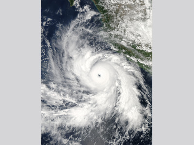
Hurricane Rick developed from a tropical wave that moved off the west coast of Africa on October 3, 2009. By 8 October, the wave had developed into an area of low pressure approximately 320 km (200 miles) east of the southern Windward Islands. The low then dissipated as it moved over South America on 11 October, re-emerging into the Pacific Ocean on 12 October. By the morning of 15 October, a new area of low-pressure formed roughly 765 km (475 mi) south-southwest of Puerto Angel, Mexico, south of Acapulco. The National Hurricane Center (NHC) upgraded the system to a tropical depression later that day. Six hours later, in the presence of low wind shear, high moisture, and sea surface temperatures (SST) near 30° C, the depression intensified into a tropical storm (and was given a name- Rick). Within 24 hours, Tropical Storm Rick strengthened into a Category 1 hurricane, with winds of 121 km/h (75 mph). The NHC declared Hurricane Rick a major Category 3 hurricane around noon on 17 October, only to then upgrade the storm to Category 4 status 40 minutes later.
As intensification continued, the storm grew in size. On 17 October, tropical storm-force winds extended 250 km (155 mi) out from the center of the Category 4 hurricane and its well-defined eye measured about 18.5 km (11.5 mi) wide. Early on 18 October, Hurricane Rick reached its peak intensity with winds of 290 km/h (180 mph) and a central pressure of 906 mbar. However, strong upper-level winds and an eyewall replacement cycle caused the hurricane to rapidly weaken. By midday on 19 October, Hurricane Rick was below major hurricane status and became a tropical storm on 20 October, 380 km (235 mi) south-southwest of lower Baja, California. At the same time, the storm’s track turned northeasterly (in response to the presence of a trough over the southwestern United States). Tropical Storm Rick made landfall near Mazatlán, Mexico, on 21 October with 105 km/h (65 mph) winds. The rugged Mexican terrain caused the storm to dissipate about seven hours after moving inland [insert link to Hurricane Decay]. Fatalities from the storm were minimal (2) and the winds and heavy rainfall associated with Rick only caused about 2 million pesos ($152,000 2009 USD) worth of damage. However, remnant moisture from Rick greatly enhanced a strong cold front moving across the U.S., which spawned severe thunderstorms over parts of the Gulf coast. At least 3 tornadoes touched down in Louisiana resulting in nearly $1 million (USD) in losses and injuring one person. In Texas, torrential rainfall from the system totaled 237 mm (9.34 inches). Fast Facts:
Sources:
Avila, Lexion A. and John P. Cangialosi. “Tropical cyclone Report: Hurricane Rick.” National Hurricane Center. 3 Dec. 2009. Web. “Hurricane Rick (2009).” Wikipedia. 2010. Web. Jeff Masters, Super Hurricane Rick the 2nd strongest hurricane ever recorded in Eastern Pacific |
 |
Please address comments and questions to hurricane@etal.uri.edu