
Introduction Hurricane Harvey was a major Atlantic hurricane in 2017 that became a tropical storm on August 17 and after three landfalls became a tropical depression over land on September 1. Hurricane Harvey made landfall in Texas on August 26 as a Category 4 hurricane. Harvey falls directly behind Hurricane Katrina (2005) as the second costliest hurricane in United States history ($125 billion 2017 USD). It was the first major hurricane to make landfall in the U.S. since 2005. As of 2018, Harvey is the wettest hurricane in U.S. history. It caused devastating flood damage, as it stalled over Southeast Texas and Southwest Louisiana and resulted in more than 10,000 people being rescued from flooded homes.
Meteorology and Forecasting
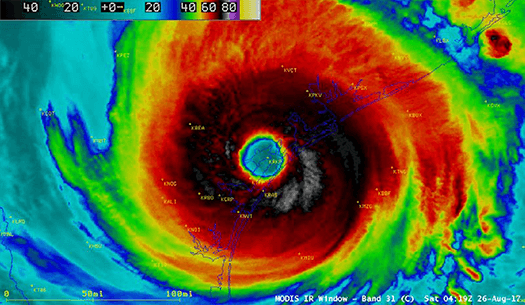
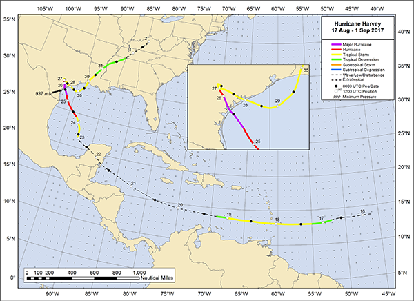
Description: On August 12th, 2017, an atmospheric wave was produced off the west coast of Africa. It propagated westward, forming a low pressure center on August 16th and a tropical depression the next day. Its strength fluctuated for several days until it rapidly intensified on August 23rd after having been exposed to light wind shear, very warm water, and high atmospheric moisture in the Gulf of Mexico. This caused the depression to intensify into a hurricane on August 24th, which grew to a category 4 hurricane by August 26th, the day it made landfall on the northern end of San Jose Island, near Rockport, Texas with winds on 115 knots (132 mph). A second landfall was reported 3 hours later southeast of Refugio on the northeast coast of Copano Bay with winds of 105 knots (121 mph). After moving inland Harvey slowed down and lost intensity, colliding with a stationary atmospheric front that stalled the storm and produced torrential rains over southeastern Texas. The storm drifted eastward and southeastward for the next couple days. On August 28th Harvey moved back over the ocean and strengthened. Harvey made a third and final landfall in Louisiana on Auguts 30 with 40 knot (46 mph) sustained winds. The storm weakened but maintained heavy rain as it moved on to Louisiana and Kentucky, where it dissipated by September 1.
Intensity: Category 4 (Saffir-Simpson Scale)
Damage
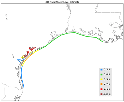
Storm tide: 6-10 ft. max. inundation above ground level (near San Antonio Bay)
Cost: $125 billion (90% confidence, range from $90 - $160 billion)
Deaths: At least 68 direct deaths, over half in Harris County (Houston, TX) due to freshwater flooding (rain). At least 35 indirect deaths due to electrocution, auto accidents, and medical needs. Highest death total in Texas since 1919. Adaptation (What was learned)
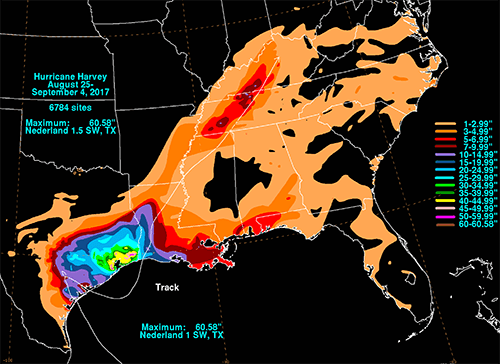
The destruction from Hurricane Harvey resulted from unprecedented rainfall that caused record flooding in the Houston area. Studies have predicted that precipitation from tropical cyclones will increase substantially over the next century due to global warming; this will occur by allowing the warmer atmosphere to hold more water vapor that can become rain. Thus, extreme rainfall from tropical cyclones will continue to become more common as the planet warms. Severe flooding from these rainfall events is exacerbated by urban expansion that gives little consideration to the risks associated with climate change. The consequences of unconstrained development were demonstrated by the disastrous flooding the Houston area experienced during and after Hurricane Harvey. Houston has expanded its population from 400,000 to 6 million residents over the past several decades, becoming a hub for the energy, space, and medical industries. This has led to unrestricted urban and residential development in coastal areas, floodplains, and reservoirs that had once relied on now non-existent prairies to absorb floodwater. To make matters worse, many residents in these areas were not notified of the associated flood risks before they bought or rented their homes because Texas law does not require it (Satija et al. 2017). In Harris County, where Houston residents were hit hardest by flooding from Hurricane Harvey, only one in six homeowners was insured with the National Flood Insurance Program (NFIP) - a federal program developed to financially protect property owners in locations vulnerable to flood risks. Adaptation to more severe extreme weather brought about by climate change is necessary to avoid disasters like the one caused by Hurricane Harvey. Some of the most important adaptive measures include development of the following:
References
Blake, E.S. & Zelinsky, D.A. (2018). National Hurricane Center Tropical Cyclone Report: Hurricane Maria (AL092017). National Hurricane Center. https://www-nhc-noaa-gov.uri.idm.oclc.org/data/tcr/AL092017_Harvey.pdf. Hanscom, G. (2014). Flood pressure: Climate disasters drown FEMA’s insurance plans. Grist. Jan 13, 2014. https://grist.org/cities/flood-pressure-how-climate-disasters-put-femas-flood-insurance-program-underwater. IPCC (2013). Climate change 2013: The physical science basis. In T.F. Stocker, et al. (Eds.), Intergovernmental Panel on Climate Change (1535 pp.). Cambridge, United Kingdom: Cambridge University Press. Kimmelman, M. (2017). Lessons From Hurricane Harvey: Houston’s Struggle Is America’s Tale. New York Times. Nov 11, 2017. https://www.nytimes.com/interactive/2017/11/11/climate/houston-flooding-climate.html. Morss, R.E., Wilhelmi, O.V., Meehl, G.A., & Dilling, L. (2011). Improving societal outcomes of extreme weather in a changing climate: An integrated perspective. Annual Review of Environment and Resources, 35, 1-25. Satija, N., Collier, K., & Shaw, A. (2017). Houston officials let developers build homes inside reservoirs. But no one warned buyers. The Texas Tribune. Oct 12, 2017. https://apps.texastribune.org/harvey-reservoirs/?utm_campaign=trib-social&utm_medium=social&utm_source=twitter&utm_content=1507778503. Trenberth, K.E., Cheng, L., Jacobs, P., Zhang, Y., & Fasullo, J. (2018). Hurricane Harvey Links to Ocean Heat Content and Climate Change Adaptation. Earth’s Future, 6. doi: 10.1029/2018EF000825. |
 |
Please address comments and questions to hurricane@etal.uri.edu