
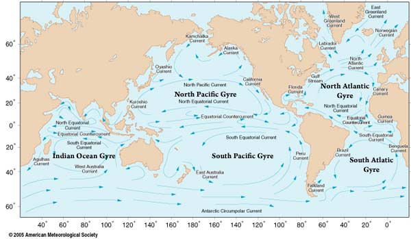
Ocean surface currents are driven by the wind. When the wind blows over the ocean, energy is transferred to the ocean surface through friction between the air and the water. This energy results in movement of the water in a direction to the right of the wind direction because of the Coriolis force (in the Northern Hemisphere). The ocean surface circulation is characterized by gyres in each ocean basin. The subtropical gyres are the strongest. The currents in each gyre are not all the same.
In the North Atlantic, the western boundary current is the Gulf Stream. The Gulf Stream begins by Florida and travels up the East Coast of the US. The Gulf Stream is the boundary between warmer surface waters to the southeast and colder surface waters along the US coast. The Gulf Stream often meanders and produces many eddies in the ocean, small offshoots from the current with a rotating circulation. Eddies can bring warmer or colder water across the Gulf Stream boundary, affecting hurricanes that might travel over them. Another current in North Atlantic that can affect hurricanes is the Loop Current. The Loop Current is located in the Gulf of Mexico on the boundary between Caribbean waters and Gulf of Mexico waters. The loop current transports warm water and has a variable path, sometimes extending quite far into the Gulf of Mexico. The path of the Loop Current, and eddies from the Loop Current, can bring warmer than typical water into the Gulf of Mexico.
This movie shows sea-surface height in the Gulf of Mexico beginning in January 1993 through 2004. The red regions are "high" relative to the surroundings; below the figure is a height scale, in cm; the flow is clockwise around a high, counter-clockwise around a low. In the open ocean, satellite-derived sea-surface height can be used to identify areas where the warm layer in the upper ocean is thick (high sea-surface height) and areas where this warm layer is thin (low sea-surface height). A thicker warm layer is more favorable for developing and supporting intense hurricanes than a thinner warm layer. Animation credit: Robert Leben, CU/CCAR.
|
 |
Please address comments and questions to hurricane@etal.uri.edu