 |
Expendable Airborne Instruments |
|
A critical piece of meteorological equipment used by both the Hurricane Hunters and NOAA hurricane aircraft is the Global Positioning System (GPS)-based dropwindsonde (dropsonde or sonde). Track forecast improvements on the order of 20% are obtained through the use of dropsonde data. The instruments are not only launched during surveillance missions, but are dropped into the windiest, rainiest, and most turbulent areas of tropical cyclones.Scientists often describe dropsondes as “Pringles cans with microprocessors and parachutes". The cylinder-shaped instrument is equipped with a high frequency radio and other sensing devices. Dropsondes are released from an aircraft about every 241.4 km (150 miles) over water. Up to four dropsondes can be deployed simultaneously. As the instrument(s) descends to the sea surface, it measures and relays to the parent aircraft a vertical profile of the atmosphere's temperature, humidity (dewpoint), and barometric pressure measurements, as well as wind data with 15 ft (5 m) vertical resolution and 2- 6 km/h (1-4 mph) accuracy. The dropsonde also receives GPS navigational signals from at least four GPS satellites and measures the Doppler shift of each signal. Measurements are taken and transmitted twice per second while the probe is in the air. Although the dropsonde is descending to the surface rapidly (a drop from 20,000 ft [6,096 m] lasts about 7 minutes), its descent is slowed and stabilized by a small parachute, which deploys immediately upon launch.
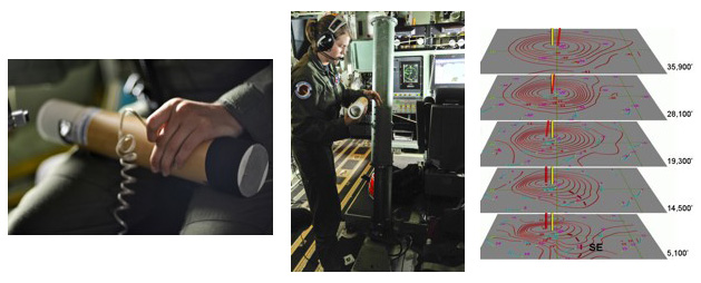 (left image) The dropsonde, one of the tools used by aircraft hurricane reconnaissance. This cylindrical package is packed with instruments that gather data such as wind speed and direction, humidity, barometric pressure and other readings, which it sends by radio back to the aircraft. Data collected from the dropsonde gives NHC forecasters a vertical profile of the storm. Image credit: U.S. Air Force Photo/Tech. Sgt. James B. Pritchett. (middle image) Staff Sgt. Shannon Smith prepares to launch a dropsonde from a WC-130J aircraft. Weather Reconnaissance Loadmasters, such as Sergeant Smith, launch dropsondes throughout the 10-12 hour flight, gathering data the Reservists provide to the NHC. Image credit: U.S. Air Force Photo/Tech. Sgt. James B. Pritchett. (right image) Analysis showing vertical slices of Hurricane Erin’s (2001) eye (data provided by a dropsonde launched from a NOAA Gulfstream jet). Red rings are lines of constant temperature (isotherms). The bull’s-eye structure at each level reveals that the closed, warm, eye extends to great heights, at least 36,000ft, even though Erin was rapidly weakening at the time these measurements were taken. |
|
Other aircraft-launched expendable probes include Airborne eXpendable BathyThermographs (AXBTs), which are small floats or buoys that are dropped to the sea surface on parachutes. Once afloat, these instruments deploy long wires with thermistors (temperature sensors), transmitting ocean temperature versus depth as the thermistors sink through the water column (an important factor in determining the intensity a hurricane may reach).
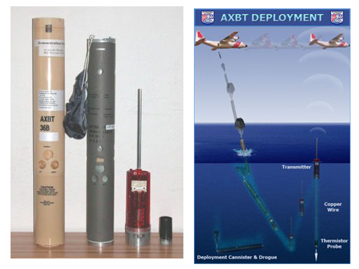 Left: AXBT instrument. Right: Deployment of an AXBT. First, the AXBT drops from an aircraft and floats on the ocean surface. Next, the temperature probe is released and takes ocean temperature measurements as it sinks. Finally, the surface transmitter relays the ocean temperature profile to the aircraft. Images provided by the United States Coast Guard's International Ice Patrol. |
|
Aircraft Expendable Current Probes (AXCPs) and Airborne Expendable Conductivity Temperature Depth probes (AXCTDs) can also be launched from reconnaissance aircraft. AXCPs measure horizontal ocean current velocity with depth (important for understanding heat transport and ocean dynamics) while AXCTDs measure ocean salinity and temperature with depth.
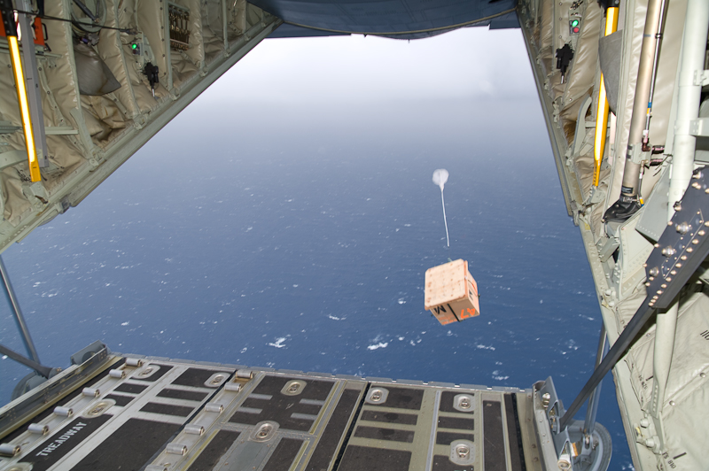 A Hurricane Hunters WC-130J aircraft drops an oceanic data buoy in advance of Hurricane Ike (2008). Image courtesy of The Hurricane Hunters, www.hurricanehunters.com. |
In addition to dropping expendable meteorological and oceanographic probes, reconnaissance aircraft may also drop packages of drifting weather buoys and/or subsurface floats. These instruments are usually deployed in advance of a hurricane to obtain key data on the air-sea interface during high sea states, including measurements of surface currents, the oceanic mixed layer, surface wave observations, and surface meteorological observations. Researchers usually place the buoys in the path of oncoming hurricanes and tropical storms, hoping the system will pass over the array that has been created.
These buoys, critical to measuring the air-sea interface, in addition to dropsondes and other probes, provide unprecedented data on hurricane characteristics necessary to further hurricane research and to improve hurricane forecasts.
References
Additional Links on HSS
Additional Resources
|
|

