
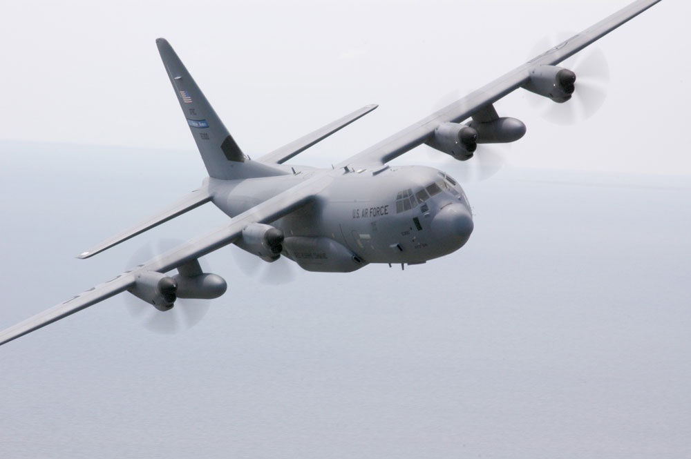
The 20 authorized aircrews of the 53rd Weather Reconnaissance Squadron of the U.S. Airforce Reserve, otherwise known as the “Hurricane Hunters”, is a component of the 403rd Wing located at the Kessler Air Force Base in Biloxi, Mississippi. It is the only operational unit in the world flying weather reconnaissance on a routine basis, providing surveillance of tropical storms and hurricanes in the Atlantic Ocean, Caribbean Sea, Gulf of Mexico and central Pacific Ocean for the NHC. The unit also flies winter missions off both coasts of the United States to support analysis and predictions of winter storm events. Data gathered by the release of a dropsonde as high as possible in the atmosphere and ahead of the storm increases the accuracy of computer weather forecasts for nor’easters and pacific winter low-pressure systems. The Hurricane Hunters use the month of February to fly Pacific storms from Elmendorf AFB, Alaska or Hickam AFB, Hawaii.
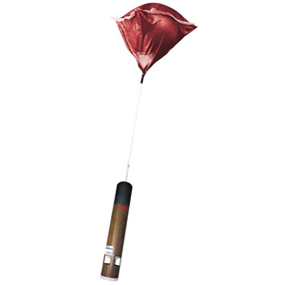
To perform their missions, the Hurricane Hunters use the WC-130J Super Hercules aircraft. This plane is actually a modified cargo plane configured with sophisticated weather instruments to measure parameters such as wind, pressure, temperature, and humidity. It can stay aloft for up to 18 hours at optimal cruise speed and usually penetrates hurricanes at an altitude of approximately 10,000 ft (3,048 m). Surface wind and other flight level data are collected during the entire route of the flight. Enhanced data are collected within the eye of the storm and at a radius of about 1609 km (100 mi) out from the eye to collect detailed data about the structure of the storm as a whole. A basic crew of five is carried on the aircraft: a pilot, co-pilot, navigator, flight meteorologist, and weather reconnaissance loadmaster. Each of these members has a specific role. The pilot and co-pilot fly the plane, keeping things safe and on time. The navigator keeps track of the aircraft’s position and movement and monitors the radar to avoid severe weather. The flight meteorologist (or aircraft reconnaissance weather officer) is the flight director in the storm environment, continuously monitoring the atmospheric data that is taken by aircraft sensors and guiding the aircraft to the hurricane’s center. Lastly, the weather reconnaissance loadmaster not only checks that all cargo are loaded properly before flight, but in-flight, they collect and record meteorological data using a parachute-borne sensor called a dropsonde, which measures and encodes weather parameters while descending to the ocean surface (for more information on this technology, see the section below).
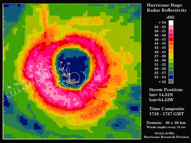
When a tropical weather system is beginning to form, the National Hurricane Center (NHC) will send the Hurricane Hunters to investigate the occurrence of counterclockwise (cyclonic) rotation and confirm the presence of a “closed system”. The mission is flown from approximately 500-1500 ft (150-450 m) above the ocean surface. The aerial reconnaissance weather officer constantly monitors a combination of both onboard instrumentation as well as the sea state in order to determine surface wind speed and direction. Once it is determined that there is a circulation within the disturbance, the mission transforms into a “fix mission” (as opposed to an “investigative mission”). During a fix mission, the crew must find the center of the storm. Flying into the eye of a mature hurricane presents significant hazards as strong updrafts in the hurricane’s eyewall can give way to equally strong downdrafts on the measure of a few hundred feet. Horizontal wind speeds can also change by more than 161 km/h (100 mph) in a few seconds of flight time as the plane moves through the eyewall, putting strains on the airplane and its crew. Because of these hazards, Hurricane Hunter flights are typically done at 10,000 ft (3,048m). A NOAA hurricane reconnaissance crew (NOAA 42) endured a near disastrous surveillance flight as they flew into the then Category 5 hurricane, Hurricane Hugo, at 1,500 ft (457.2 m). As they flew through the storm’s eywall they encountered sustained winds of 297.7 km/h (185 mph) (gusting to 315.4 km/h [196 mph]) and extreme updrafts and downdrafts (32-72 km/h [20-45 mph]). The massive jolts rocked the aircraft, causing gear such as tools, computers, all items in the galley, and even the 200 lb life raft to be dangerously thrown about the aircraft’s interior. The cockpit gravitational force(G)-meter, became pegged at 5.6 G's and -3.9 G's (positive, or "upward" g, drives blood downward to the feet and a typical person can handle about 5 g [49m/s²] before losing unconsciousness, modern pilots 9 g [88 m/s²]; resistance to "negative" or "downward" g, which drives blood to the head, is much lower, 2 -3 g [20 m/s² to 30 m/s²] ). Upon reaching Hugo’s eye, one of the engines exploded and had to be shut down. In the calm of the hurricane’s eye, the plane made repeated circles, a risky maneuver with the loss of one engine. NOAA 42 was able to successfully exit the hurricane after a U.S. Air Force Hurricane Hunter plane, which was also sampling Hugo, inspected the aircraft and confirmed that there was no other visible damage.
After the flight, NOAA 42 received a full maintenance overhaul. No hurricane-related damage to the aircraft was found, except for a missing de-icing boot on one engine and a failed fuel control sensor on the engine that caught fire. Engineers analyzing the G-force data could only conclude that luck and the toughness of the P-3 airplane saved the crew from destruction (at that time, no hurricane hunter aircraft had ever taken more than 3 G's). During a fix mission, the plan will fly an “alpha pattern” to get an overall look at the storm. This pattern typically consists of 194.5 km (105 nm) length legs and is repeated two times during the mission. During the flight, weather data is continuously collected and transmitted back to the NHC via satellite communications. After two passes through the eye (fixes), the winds in all four quadrants have been measured. At this point, the plane would typically continue the alpha pattern, making two more fixes before heading home.
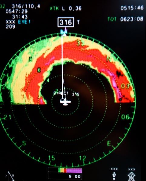
The WC-130J aircraft features on-board instrumentation such as radars. Meteorological radar is one of the most essential pieces of equipment carried by reconnaissance planes. The radar transmitter sends pulses of electromagnetic radiation and then measures the amount of radiation that is scattered back to the radar receiver from different forms of precipitation. By measuring the amount of radiation, one can establish the concentration of precipitation and in determining the radiation return distance (how long it takes the radiation to “bounce” off a particle and return back to the radar receiver), researchers can calculate the distance to the scattering particles. Big particles (e.g. hailstones) scatter more radiation, whereas smaller particles (e.g. raindrops) scatter much less radiation (tiny ice particles will not provide any detectable amounts of scatter). What is seen on radar, therefore, is a measure of the concentration of precipitation in the air, weighted towards the bigger raindrops and ice particles. A very large area can be surveyed in just a few seconds as the radar antennae sweep over locations in a circular pattern, all the while transmitting and receiving pulses of radiation. Another key piece of instrumentation on the WC-130J reconnaissance aircraft is the stepped-frequency microwave radiometer (SFMR, or “smurf”). This is a state-of-the-art instrument designed to continuously and accurately measure the ocean surface winds directly below the airplane. As a plane flies through a storm, the SFMR constantly senses microwave radiation naturally emitted from seafoam that is created by winds at the surface. Onboard computers then determine wind speeds based on the levels of microwave radiation detected. The SFMR can also determine rainfall rates within a storm system. This information, in addition to wind speed data gathered at flight level, provides the NHC with structural details of the storm. Aircraft reconnaissance is considered to be the most direct method of measuring the winds of a hurricane. Data provided by the Hurricane Hunters is vital to tropical cyclone forecasting and makes possible the advance warning of hurricanes and increased accuracy of hurricane predictions and warnings. |
 |
Please address comments and questions to hurricane@etal.uri.edu