
During World War II, radar technology was developed to detect aircraft. When using this early radar, it was discovered that precipitation blurred or hid the signal of incoming aircraft. Radar technicians would notice "ghost echoes" on their scopes but did not realize at first that they were caused by thunderstorms. Once they did, Army and Navy meteorologists soon learned how to use radar as a weather-monitoring tool. In 1957, the U.S. Weather Bureau (which would become today’s National Weather Service (NWS)) established the United States' first weather radar network to survey the coastline and help to warn of impending tropical cyclones. The radar monitoring system was upgraded in the 1990s to use Doppler technology. This technology provides rainfall estimates, wind estimates, possible locations off tornadoes within a system's spiral bands, as well as the center location of a tropical cyclone. Radar works by transmitting pulses of energy and then measuring the amount of energy that is returned to the radar receiver from various forms of precipitation (raindrops, snowflakes, hailstones, etc.). By measuring the amount of reflected radiation, one can establish the concentration of precipitation. Big particles such as hail scatter more radiation whereas small particles like raindrops do not scatter as much radiation (and tiny ice particles will not provide any detectable amounts of scatter at all). What is seen on radar, therefore, is a measure of the concentration of precipitation in the air, weighted towards the bigger raindrops and other particles. In determining the radiation return distance (how long it takes the radiation to “bounce” of a particle and return back to the receiver), meteorologists can calculate the distance to those particles.
NOAA/NWS radar reflectivity loop of Hurricane Jeanne's landfall in Florida in late September of 2004. The colors in the image are quantified in the color bar on the right side. The numbers in the color bar are in units of dbZ, which is a standard unit of measurement of radar reflectivity. The higher the number, the higher the radar reflectivity. Radar reflectivity increases if the number of raindrops (or other hydrometeors) increases in a given volume of air or if the size of the raindrops increases in that volume of air. Therefore, higher reflectivity typically indicates higher rainfall rate. Animation credit: NOAA National Weather Service (NWS).
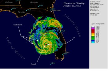
When a hurricane is within approximately 325 km (200 miles) of the coast, it can be monitored by land-based weather radar. These radars provide detailed information on hurricane wind fields, rain intensity, and storm movement. As a result, local NWS Weather Forecast Offices are able to provide short-term warnings for floods, tornadoes, and high winds for specific areas. The assimilation of radar data into numerical weather prediction (NWP) models has been shown to improve the prediction of thunderstorm structure and the amount of precipitation expected within 0-6 hours. Two important radar products are used by forecasters:reflectivity and radial wind velocity. Both tools allow forecasters to provide much more timely and accurate warnings.
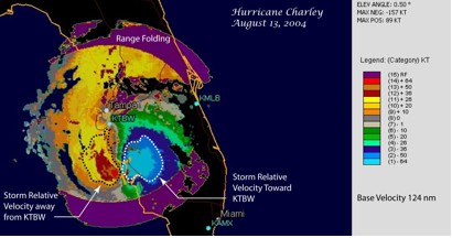
Radial wind velocity products give forecasters important information about the system’s wind speed and direction. It shows the velocity of the precipitation either toward or away from the radar. Precipitation moving toward the radar has negative velocity (blue and green colors) and precipitation moving away from the radar has positive velocity (yellow and orange colors). The purple colors indicate areas of “range folding” farther than about 150 mi from the radar in which velocities cannot be determined.
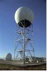
Next-Generation Radio (NEXRAD) is a network of 158 high-resolution Doppler Radars operated by the NWS. The network detects precipitation intensity (reflectivity) and atmospheric movement (radial velocity) across a wide column of the atmosphere, providing forecasters with a valuable cross-section analysis of a storm. The system operates in two modes, a slow scanning mode when there is little or no activity in the area, and a precipitation mode with a faster scan time for tracking active weather.
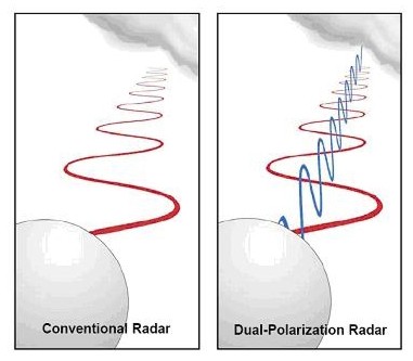
In the spring of 2013, 122 NWS radar sites were upgraded throughout the United States. These sites have been enhanced with dual-polarization (“dual-pol”) radar technology. Dual-pol radar sends and receives both horizontal and vertical pulses of energy. This produces a much more detailed picture of the size and shape of objects in the sky and provides meteorologists the ability to more accurately track and assess hazardous weather events and produce more descriptive weather warnings.
|
 |
Please address comments and questions to hurricane@etal.uri.edu