
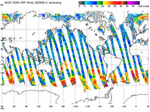
There is very little surface data available over the ocean. Weather and research buoys are few and far between and concentrated near coastlines. Measurements of the ocean winds from satellite scatterometers provide vital information for global weather forecast models and hurricane forecasting. Scatterometer data tells forecasters the intensity and direction of the near surface wind field. The surface wind field is very useful information for hurricane modeling and forecasting. The data from scatterometers also goes into storm surge models. Scatterometers measure the near surface winds with microwave radiation. The satellite emits microwaves and measures the reflection and scattering of the microwaves. By comparing the background microwaves and to the reflected microwaves from different angles, the near surface winds over the ocean can be calculated. The Advanced Scatterometer Instrument (ASCAT) on the MetOp satellite operated by the European Organisation for the Exploitation of Meteorological Satellites (EUMETSAT) provides surface wind data over a large portion of the Earth. The WINdSat instrument on the Coriolis satellite (operated by the US Department of Defense and US Navy) also provides surface wind data.
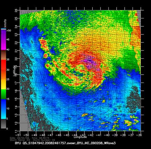
Below is an example of the data collected by the QuikSCAT satellite for hurricane Ike in 2008.
The Quick Scatterometer (QuikSCAT) satellite operated until the end of 2009. Originally QuickSCAT was a stop-gap mission when a previously orbiting satellite (NSCAT) unexpectedly failed. The purpose of the QuickSCAT mission was to measure near surface wind speed and direction over the oceans. These measurements could be made in most cloud cover or weather conditions. QuickSCAT was in a polar orbit and measured near surface wind speed and direction over 90% of the Earth’s surface in one day. |
 |
Please address comments and questions to hurricane@etal.uri.edu