 |
Weather Buoys |
|
Moored buoys are considered to be the “weather sentinels” of the sea and are deployed by countries all over the world. Larger moored buoys are used near shore, while smaller drifting buoys are used farther out at sea. For the U.S., a significant network of buoys (and coastal stations) is operated and maintained by the National Oceanic and Atmospheric Administration’s (NOAA’s) National Data Buoy Center (NDBC). The buoys are deployed in coastal and offshore waters from the western Atlantic to the Pacific Ocean around Hawaii, and from the Bering Sea to the South Pacific. Moored buoys provide standard, hourly observations of wave height and period, but some buoys can also measure and transmit data on barometric pressure, air and sea surface temperatures, as well as wind speed, direction, and gustiness. Even the direction of wave propagation can be measured on many of NOAA’s buoys.
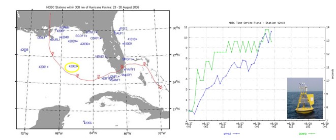 (left) Map displaying Hurricane Katrina's track (2005) and NDBC Stations. Katrina's track is shown in red with the start of each day numbered on the line. Stations (in blue text) provided data on wind speed, barometric pressure, wave height, and wave period. (Image Credit: NOAA/NDBC)
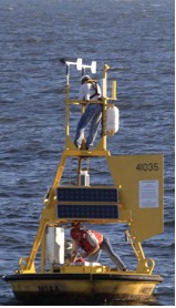
(right) Significant wave height (blue line) and dominant wave period recorded during Hurricane Katrina (2005) at Station 42003 (circled in yellow on the map to the left). In the span of one day, both wave height and period increased 3-fold. Data was lost after 08/28/05Z because the buoy capsized. This is this first capsizing of a 10-meter buoy in the Gulf of Mexico in NDBC's 30-year history of operation. A 3-meter replacement buoy was deployed 12/05/08 (shown in the image here). (Image/graph credit: NOAA/NDBC) |
|
The buoys can face rough weather and are anchored using anything from chains in shallow waters to heavy-duty, polypropylene rope in deeper waters. The buoys are serviced every two years to try to keep up with corrosion. Maintenance work is mostly performed by the NDBC, although the U.S. Coast Guard may repair some of the more remote buoys.
 Two technicians with NOAA’s National Data Buoy Center repair a weather buoy off the North Carolina coast damaged by Hurricane Katrina. Image credit: NOAA. |
|
Recently, the NDBC expanded and enhanced its existing network of buoys with the addition of hurricane buoys in the western North Atlantic Ocean. These buoys can measure winds, waves, and barometric pressure, as well as air and sea temperatures. Data gathered can then be used to determine hurricane formation or dissipation, the extent of wind circulation, and center location. The hurricane buoys are more robust than other weather buoys because they contain an internal back-up system and will allow NOAA to attain more data in an area where hurricanes frequently occur.
 NOAA’s new hurricane buoys on dock, waiting to be deployed from Gulfport, Mississippi (Image credit: NOAA). Wind, wave, barometric pressure and temperature data from these new stations will help the National Hurricane Center (NHC) more accurately determine formation or dissipation, extent of wind circulation, and center location of the tropical cyclones. |
|
Weather buoys are an incredibly valuable part of the hurricane warning system. Surveys of meteorologists have shown about 40% of the National Weather Service's (NWS) marine warnings and advisories are based, at least in part, on NDBC's meteorological data.
References
|
|

