
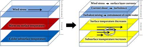
In Hurricane Development: From Birth to Maturity, hurricane-induced transfer of heat from the ocean to the atmosphere through evaporation is discussed. Evaporation of water at the sea surface is enhanced by a hurricane’s surface winds, which transport water vapor into the troposphere. While the sea surface cools in response to this evaporation, the magnitude of the cooling is generally small compared to the cooling that results from other processes caused by the hurricane’s surface winds. To understand these other processes, it is necessary to look beneath the sea surface. In the tropical oceans, the sea surface temperature (SST) is much warmer than that of the deeper water below the surface. In an ocean layer called the thermocline, the transition from warm water to cold water occurs rapidly. Above the thermocline, in the oceanic mixed layer, the water is fairly uniform in temperature and is approximately as warm as the sea surface. Below the thermocline, the water is also nearly uniform in temperature, but it is cold. The thickness of the oceanic mixed layer varies in different parts of the tropical oceans. In most parts of the Gulf of Mexico, for example, the oceanic mixed layer during the summer and fall is relatively thin and the thermocline is relatively close to the surface. In the Caribbean Sea, the oceanic mixed layer is relatively thick and the thermocline is deeper. The primary process responsible for cooling the sea surface under a hurricane is vertical mixing. Vertical mixing occurs because the hurricane’s surface winds exert a stress on the ocean surface due to friction, generating ocean currents in the oceanic mixed layer. Vertical shear of the currents in the upper ocean then leads to turbulence. Turbulence mixes and entrains the colder water from the thermocline up into the oceanic mixed layer, thereby thickening and cooling the oceanic mixed layer. Some of this colder water makes its way up to the sea surface. Since this vertical mixing process happens within a few hours, it usually cools the sea surface underneath a hurricane, restricting evaporation and therefore limiting the heat available to the hurricane for intensification and maintenance.
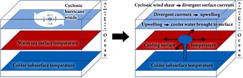
Another process that can cool the sea surface under a hurricane is upwelling. Since the hurricane’s surface winds are cyclonic (see Hurricane Structure and Primary Circulation), the wind stress on the ocean surface is also cyclonic, causing the currents at the sea surface to be cyclonic initially. Just like in the atmosphere, however, the Coriolis Force deflects the currents to the right (in the Northern Hemisphere), and the net result is that on average, the currents in the ocean are directed outward away from the storm center. As the water in the upper ocean moves away from the storm center, colder water from below moves upward towards the sea surface to fill the void. This process is called upwelling. Unlike vertical mixing, upwelling caused by a hurricane usually occurs over a period of a half a day or more, so its contribution to sea surface cooling only occurs underneath the storm if storm is propagating slowly; fast-moving storms are gone before upwelling has an impact on the sea surface temperature. Regardless, upwelling by a hurricane can have strong influences, both positive and negative, on the biology of the ocean.
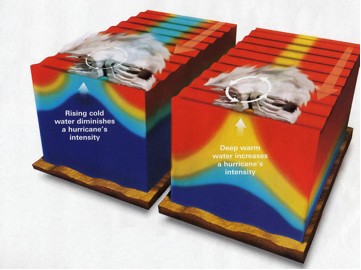
The thicker the oceanic mixed layer is before a hurricane arrives, the less vertical mixing and upwelling can cool the sea surface. In the image below, the combined effects of vertical mixing and upwelling on hurricane intensity are shown if the oceanic mixed layer is initially thin versus if the oceanic mixed layer is initially thick.
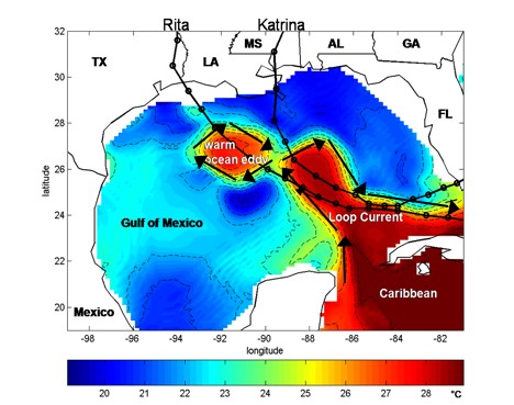
At the boundaries of different water masses, called oceanic fronts, strong ocean currents often exist. One of these currents, called the Loop Current, resides in the Gulf of Mexico. The Loop Current forms the boundary between the water in Caribbean Sea, which has a deep oceanic mixed layer during hurricane season, and the surrounding Gulf of Mexico Common Water, which has a shallow layer during hurricane season. Also, the Loop Current sheds warm ocean eddies in the ocean, which have a deep oceanic mixed layer in the center. Recent research suggests that a hurricane’s cold wake can be affected not only by the change in oceanic mixed layer depth across the Loop Current and across a warm ocean eddy, but also by the ocean currents within the Loop Current and the eddies.
This movie shows sea-surface height in the Gulf of Mexico beginning in January 1993 through 2004. The red regions are "high" relative to the surroundings; below the figure is a height scale, in cm; the flow is clockwise around a high, counter-clockwise around a low. In the open ocean, satellite-derived sea-surface height can be used to identify areas where the warm layer in the upper ocean is thick (high sea-surface height) and areas where this warm layer is thin (low sea-surface height). A thicker warm layer is more favorable for developing and supporting intense hurricanes than a thinner warm layer. Animation credit: Robert Leben, CU/CCAR.
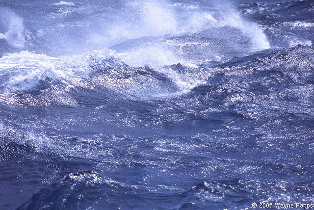
While a hurricane’s surface winds do generate upper-ocean currents, this process of current generation does not happen directly. The winds build up waves at the sea surface, and some of the energy from the winds goes into growing and propagating these waves. When the waves break, energy is transferred downward into the ocean currents, and sea spray is blown off of the wave crest into the atmosphere. Evaporation of sea spray can contribute to the transfer of heat from the ocean to the atmosphere and may reduce the wind friction over the sea surface, thereby potentially impacting a hurricane’s intensity.
|
 |
Please address comments and questions to hurricane@etal.uri.edu