
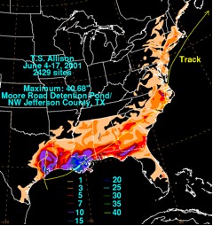
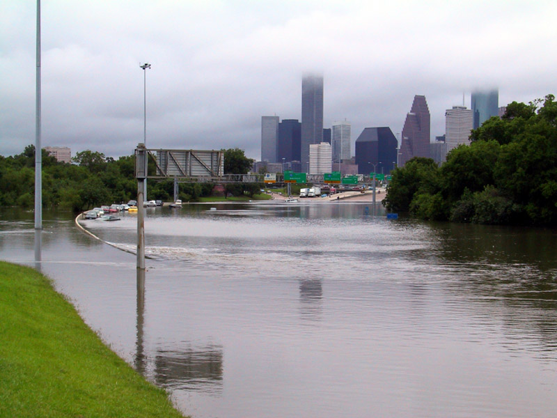
In addition to high winds and storm surge, hurricanes threaten coastal areas with their heavy rains. All tropical cyclones can produce widespread torrential rains, which cause massive flooding and trigger landslides and debris flows. Flash flooding, a rapid rise in water levels, can occur quickly due to intense rainfall over a relatively short period of time. As a weakened Hurricane Camille passed over the Virginias in 1969, it produced a burst of 12 to 20 inch rainfalls with local totals of up to 31 inches. Most of this rain occurred in 3 to 5 hours and caused catastrophic flash flooding. Longer term flooding on rivers and streams can also persist for several days after a storm. In 2001, Tropical Storm Allison brought rain to the Texas and Louisiana coasts for nearly 6 days. Thirty-seven inches of rain fell in the port of Houston, TX, and nearly 30 inches inundated Thibodaux, LA. Tropical Storm Allison was actually the most costly tropical storm in U.S. history with more than $5 billion in flood damage to southeast Texas and southern Louisiana.
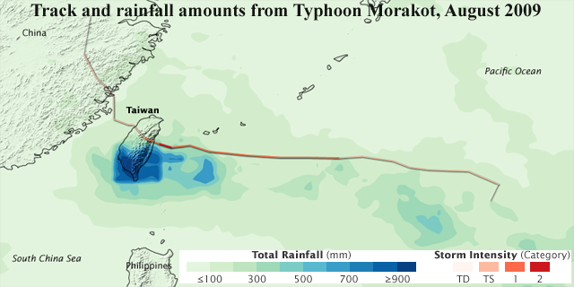
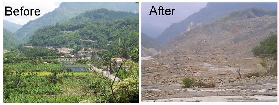
Typhoon conditions on Taiwan can bring very heavy rainfall due to its high terrain. Typhoon Morakot (August 2009) caused severe damage to the southern part of Taiwan with record-breaking rainfall: 2,900 millimeters (114 inches) in 3 days! The highest, single-day, regional record was broken on August 8th, at 1403 millimeters (55 inches). These exceptional rainfall totals brought much destruction to infrastructure and communities, causing extensive flooding and mudslides. This event is regularly compared to another devastating flood event for central Taiwan that took place in August 1959.
Rain-triggered flooding is not just limited to coastlines as the reach of a large hurricane can cause deadly flooding well inland. Since 1970, nearly 60% of the 600 deaths within the U.S. due to floods associated with tropical cyclones occurred inland from the storm's landfall. Of that 60%, almost a fourth (23%) of U.S. tropical cyclone deaths occur to people who drown in, or attempting to abandon, their cars. Many avoidable deaths occur due to hurricane flooding when motorists drive into floodwaters thinking they can safely drive through the water. As little as one foot of moving water can sweep a car off the road. Six inches of moving floodwater can sweep an adult off their feet. The Turn Around, Don’t Drown national campaign initiated by the National Weather Service (NWS) and the Federal Alliance for Safe Homes (FLASH) is an excellent public safety movement that has saved lives across America by reminding motorists to NEVER drive through flooded streets if they cannot see the road.
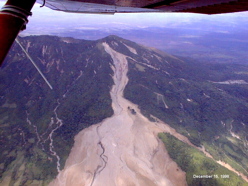
Human interaction and land use can also affect how rainfall may impact a region. Areas lacking a naturally occurring base layer of sediment, plants, trees, etc. will be more apt to erode or washout with large volumes of rainfall or flowing water. Specifically, regions that have experienced deforestization will not have the same absorptive abilities as a previously forested area. This is due to the lack of root structures that once existed, which held plants and trees to the ground while also anchoring the soil. Deforested areas will therefore experience greater water runoff, further contributing to any localized flooding, and will erode at a faster rate in comparison too similarly elevated, naturally-occurring, regions (i.e. fields that exist and were not created by clear cutting). Increased flooding and erosion rates may cause landslides in some areas, especially mountainous regions. A landslide is a geological phenomenon in which ground movements, such as rock falls, deep slope failures, and shallow debris flows, occur and are driven downward by gravity. Landslides are caused when the stability of a slope changes from stable to unstable. This change in stability can occur when: groundwater pressure destabilizes the slope; weakening occurs due to heavy saturation; erosion occurs due to loss of vegetative structure; or volcanic eruptions or earthquakes cause destabilization or liquefaction. Human activity can impact and diminish slope stability through blasting and construction as well as through agriculture and/or forestry. These actions alter the landscape and the amount of moisture retained in the soil. Landslides can cause the destruction of crops, roads, bridges, and even villages. While most US coastlines prone to frequent hurricane activity do not have nearby elevation increases capable of producing landslides, locations in Central America and the Northwest Pacific Ocean that are susceptible to tropical cyclones are vulnerable. For example, in October 1998, rainfall from Hurricane Mitch exceeded 254 mm (10 in) in Honduras and Nicaragua and triggered numerous landslides. These landslides collectively destroyed over 25 villages across both countries. This then contributed to the homelessness of 20% of Honduras’ population following the passage of the storm.
|
 |
Please address comments and questions to hurricane@etal.uri.edu