The 1930 Atlantic hurricane season was exceptionally quiet with only two tropical storms known to have formed. One of them would prove to be one of the deadliest hurricanes in Atlantic history.
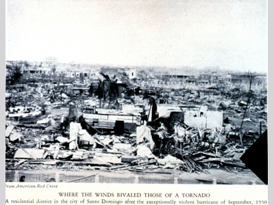
There were no ships in the Atlantic near enough to this storm to know the exact location of its development, but it is likely that the hurricane formed south of the Cape Verde islands from a tropical wave. Being a tropical storm when first observed, the system gradually intensified as it tracked westward. The storm probably became a hurricane on 31 August while located 620 km (385 mi) east of Guadeloupe, though it was first observed to be a hurricane on 1 September based on wind reports from Dominica and Barbados. After passing Dominica and entering the Caribbean Sea, the hurricane was at Category 2 status with winds of 161 km/h (100 mph). It strengthened into a major Category 3 hurricane before passing to the south of Puerto Rico on 2 September. Although it was close to land, the hurricane was able to intensify because it’s forward motion slowed to a 13 km/h (8 mph) crawl before landfall. It strengthened into a strong Category 4 hurricane with winds of 241 km/h (150 mph) before making landfall near the city of Santo Domingo in the Dominican Republic. The storm proceeded to move west-northwest across Hispaniola, weakening rapidly due to the mountainous terrain on the island. Six hours after landfall the storm had been downgraded to a tropical storm. Continuing its forward motion, the tropical storm struck southeastern Cuba on 4 September with 97 km/h (60 mph) winds. After moving into the Gulf of Mexico, the storm began to curve towards the northeast. On 9 September, the tropical storm made landfall in the United States near Tampa, Florida with winds of 64 km/h (40 mph). The storm reorganized over the Gulf Stream after crossing the Florida peninsula and was able re-attain hurricane status while located 153 km (95 mi) southeast of Cape Fear, North Carolina. It strengthened as it accelerated northeast then eastward. The hurricane reached a second peak of 161 km/h (100 mph) on 13 September about 500 km (310 mi) north of Bermuda. The colder waters of the North Atlantic Ocean caused it to gradually weaken with the storm finally dissipating on 17 September in the central Atlantic west of the Azores. There was said to be great damage on the island of Dominica, where the hurricane passed either close to or directly over. There, damage to crops and buildings were heavy and 20 people were killed. Puerto Rico received up to 15.2 cm (6 in) of rain as the storm passed. In the Dominican Republic, damage was very severe. A path of destruction 32 km (20 mi) wide was seen after the hurricane moved through. The hurricane completely destroyed almost half of the entire city including the near total destruction of three entire districts. The loss of life in this country was great. The true death toll will probably never be known, but it is estimated that at least 2,000, or even as high as 8,000 people were killed during the event. Damage outside of the immediate Santo Domingo area was insignificant. The strong winds disabled communication infrastructure in the city, making it initially difficult to assess the destruction. The president of the Dominican Republic, Rafael Leónidas Trujillo, personally organized relief work after the storm, almost immediately deploying the country’s entire military to assist in the aftermath. The overall damage was about $50 million (1930 USD). Fast Facts:
Sources:
Hartwell, F. Eugene. “The Santo Domingo Hurricane of September 1 to 5, 1930.” Monthly Weather Review. August 1930. Pp. 362-364. Web. “1930 Dominican Republic Hurricane.” Wikipedia. 2009. Web. “1930 Atlantic Hurricane Season.” Wikipedia. 2009. Web. “Deadliest Atlantic Hurricanes.” Weather Underground. 2010. Web. |


