
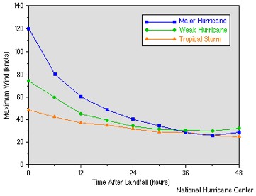
In Hurricane Genesis: Birth of a Hurricane, the formation of tropical depressions in the Earth’s atmosphere is discussed. The formation of a tropical depression can become the birth of a hurricane. In Hurricane Development: From Birth to Maturity, the maturation of a tropical depression into a hurricane is described. In this section, the causes of hurricane decay or death are reviewed. Just as there are many factors that contribute to the birth and survival of a hurricane, there are also many causes for a hurricane to weaken and/or die. Landfall usually causes a hurricane to quickly decay (for more detail see, Interaction between a Hurricane and Land). Hurricanes require evaporation from the warm ocean surface to survive (see Hurricane Development: From Birth to Maturity). Once a hurricane makes landfall, it is separated from its ocean energy source, and hence, can no longer extract heat from the ocean. Since the air masses over land are drier and contain more aerosol particles than over the ocean, less moisture is carried into the storm, cloud coverage lessens, and air is cooled and then sinks, disrupting the hurricane’s secondary circulation and hindering critical thunderstorm development (see Hurricane Development: From Birth to Maturity). To a lesser extent, the increased roughness of the land surface also weakens a hurricane as increased friction causes a reduction in surface circulation. Even if a hurricane remains over the ocean, once the storm moves northward (in the Northern Hemisphere) out of the tropical ocean and into the mid-latitudes, it begins to move over colder water, again losing the warm water source necessary to drive the hurricane. As less moisture is evaporated into the atmosphere to supply cloud formation, the storm weakens. Sometimes, even in the tropical oceans, colder water churned up from beneath the sea surface by the hurricane can cause the hurricane to weaken (see Interaction between a Hurricane and the Ocean). Even when the ocean conditions are favorable for the hurricane to be maintained, a hurricane may encounter an area of particularly dry and dusty air, such as the Saharan Air Layer (SAL), causing the hurricane to weaken, though the role of the SAL is being debated.
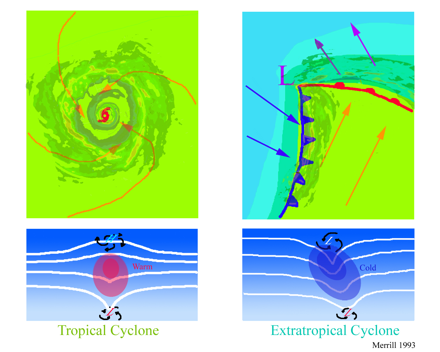
Hurricane decay can also be caused by strong vertical wind shear, a change in wind direction or speed with height. This change in wind speed or direction with height can enhance the mixing of drier environmental air into the storm eyewall leading to downdrafts, which inhibit intensification. Fast, upper-tropospheric winds can create very high values of wind shear and can separate cloud tops from their bases and cause the vertical circulation around a hurricane’s eyewall to tilt. As heat and moisture at upper levels are advected away from the low-level circulation of the hurricane, its development is inhibited. Midlevel warming within the storm’s center also reduces convective activity and inhibits intensification. Without a strong secondary circulation, a hurricane cannot be sustained (see Hurricane Development: From Birth to Maturity). The response to vertical shear partially depends on the storm circulation, so the response to similar values of vertical shear can vary from storm to storm. Vertical wind shear is common in the mid-latitudes, although it can also occur over the tropical oceans where it cannot only weaken a hurricane but also help to prevent one from forming in the first place (see Hurricane Genesis: Birth of a Hurricane). When a hurricane moves into the mid-latitudes, it may be absorbed by a different kind of low-pressure weather system called an extratropical cyclone. Extratropical cyclones are responsible for much of the sensible weather (such as rain and snow) that people who live in the mid-latitudes experience, especially during the winter months. Unlike hurricanes, extratropical cyclones require areas of sharp horizontal temperature contrasts, called fronts, to form. Although the mechanisms for creating an extratropical cyclone are quite different than the mechanisms for creating a hurricane, the added moisture and energy from an absorbed hurricane can sometimes cause an extratropical cyclone to rapidly intensify, as in the case of the “Perfect Storm” in late-October 1991. Sometimes, a hurricane itself may transition into an extratropical cyclone when it moves into the mid-latitudes. This process, called extratropical transition (ET), involves the hurricane losing its warm core, which weakens and becomes a cold core low, while the wind field and cloud field expand in size. Once extratropical transition is complete, the storm is sustained from energy that it extracts from the environmental wind field (in the presence of temperature fronts) instead of energy from the ocean. During extratropical transition, a cyclone frequently produces intense rainfall and strong winds and has increased forward motion, so that such systems pose a serious threat to land and maritime activities. Hurricane Irene (1999) is a good example of a hurricane which underwent an explosive extratropical transition. The storm began in the Caribbean and then moved across Cuba and southern Florida. As it rapidly accelerated into the North Atlantic, the hurricane became an intense extratropical low over the maritime provinces of southeast Canada, actually exhibiting its strongest winds after its transition.
|

 |
Please address comments and questions to hurricane@etal.uri.edu