
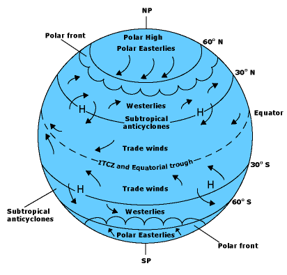
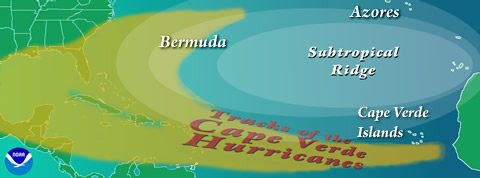
The movement of a hurricane from one location to another is known as hurricane propagation. In general, hurricanes are steered by global winds. The prevailing winds that surround a hurricane, also known as the environmental wind field, are what guide a hurricane along its path. The hurricane propagates in the direction of this wind field, which also factors into the system’s propagation speed. While each storm makes its own path, the movement of every hurricane is affected by a combination of factors, as described below. In the tropics, where hurricanes form, easterly winds called the trade winds steer a hurricane towards the west. In the Atlantic basin, storms are carried by these trade winds from the coast of Africa, where they often develop (see Hurricane Genesis: Birth of a Hurricane), westward towards the Caribbean Sea and the North American coasts. Embedded within the global winds are large-scale high and low-pressure systems. The clockwise rotation (in the Northern Hemisphere) of air associated with high-pressure systems often cause hurricanes to stray from their initially east-to-west movement and curve northward. One such high-pressure system, often referred to as the Bermuda High (Azores High) (depending on its location) or more generally as a subtropical ridge, often dominates the North Atlantic Ocean. Atlantic hurricanes typically propagate around the periphery of the subtropical ridge, riding along its strongest winds. If the high is positioned to the east, then hurricanes generally propagate northeastward around the high’s western edge into the open Atlantic Ocean without making landfall. However, if the high is positioned to the west and extends far enough to the south, storms are blocked from curving north and forced to continue west, putting a large bulls-eye on Florida, Cuba, and the Gulf of Mexico, as was the case during much of the 2004 and 2005 Atlantic hurricane seasons.
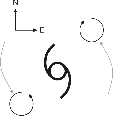
In addition to the steering flow by the environmental wind, a hurricane drifts northwestward (in the Northern Hemisphere) due to a process called beta drift, which arises because the strength of the Coriolis force increases with latitude for a given wind speed. The details of beta drift are beyond the scope of the discussion here, but the effect is summarized in the following graphic. Since beta drift involves a hurricane’s ability to modify the environmental wind field, the impact of beta drift on the hurricane’s track changes if the hurricane’s size changes.
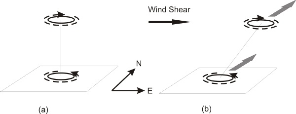
As a hurricane propagates northward out of the tropics, the environmental wind field often becomes weak, causing the hurricane to slow down, stall, or move erratically, especially if the hurricane is away from the influence of strong high or low pressure systems. Once a hurricane reaches further north and enters the mid-latitudes, the environmental wind field usually becomes southwesterly or westerly, often around the western side of a high pressure system and east of a trough of low pressure, causing the hurricane to recurve to the right and accelerate towards the north, northeast, or east. If a hurricane encounters the jet stream while in the mid-latitudes, the storm may accelerate very quickly, allowing it to reach high latitudes, especially if it is travelling over a warm ocean current such as the Gulf Stream. Most of the time, however, land interaction, cold ocean water, or vertical wind shear prevents a hurricane from surviving very far north of the tropics (see Hurricane Decay: Demise of a Hurricane). While the environmental wind field and beta drift are generally the most important factors determining hurricane movement, other processes may also play a role. When vertical wind shear exists, the hurricane’s rotational wind field may tilt with height. By displacing the cyclonic (counterclockwise in the Northern Hemisphere) circulation in the lower troposphere downstream from the anticyclonic (clockwise in the Northern Hemisphere) circulation in the upper troposphere, the vertical wind shear may allow the lower circulation to push the upper one and the upper circulation to push the lower one, having a combined effect of changing the track of the entire hurricane.
If a hurricane is in close proximity to another similarly-sized atmospheric circulation, such as a second hurricane, the two circulations may orbit cyclonically around a common point between them. This motion is known as the Fujiwhara effect. Land interaction also may change the track of a hurricane, especially when the land is mountainous. Mountains can disrupt the center of a hurricane’s circulation, which may then reform on the other side of the mountains away from the trajectory of the hurricane’s track prior to crossing the mountains.
Hurricane movements can be very unpredictable, sometimes performing loops, hairpin turns, and sharp curves. Forecasters track hurricane movements and predict where the storms will travel as well as when and where they will reach land. For more information on how these weather systems are observed over time, please see Hurricane Observation. |
 |
Please address comments and questions to hurricane@etal.uri.edu