
The beginning of life for any hurricane is a pre-existing disturbance, an area of low pressure, over the tropical ocean. However, several other ingredients are also required for a system to become a hurricane. In this section, the formation of a tropical depression, which is the weakest type of tropical cyclone, is discussed. The formation of a tropical depression can lead to the birth of a hurricane. In Hurricane Development: From Birth to Maturity, the maturation of a tropical depression into a hurricane is described. In Hurricane Decay: Demise of a Hurricane, the causes of hurricane decay are reviewed. Setting the Stage for Hurricane Formation
Having a pre-existing disturbance is not the only ingredient necessary for a hurricane to form. This disturbance must be located in an environment that is favorable for development. Favorable conditions include:
Formation of a Tropical Depression
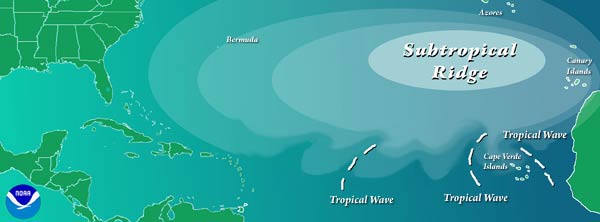
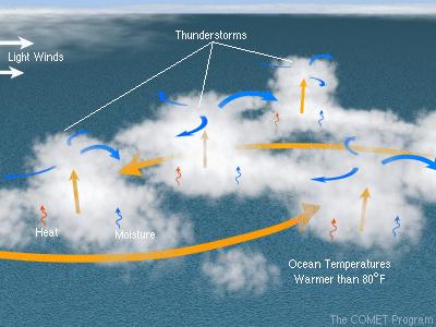
Even when favorable conditions are present, a tropical depression still may not form. For this reason, understanding and forecasting the genesis of a tropical depression is a difficult challenge. The leading theory for tropical depression formation begins with a pre-existing disturbance. This disturbance consists of an array of thunderstorms in an atmosphere where sufficient moisture or water vapor is present. In the North Atlantic and Northeast Pacific Oceans, most of the atmospheric disturbances that eventually form a hurricane are associated with an African easterly wave. An African easterly wave is an area of low atmospheric pressure that is embedded in the easterly trade winds and generally forms over Africa within the intertropical convergence zone (ITCZ). The details of how an African easterly wave forms are complex, but ultimately, development is due to the strong temperature contrast between the hot and dry Sahara Desert and the much cooler and wetter Gulf of Guinea coast. In other ocean basins, different kinds of atmospheric disturbances become tropical depressions. For example, many Northwest Pacific typhoons originate from a disturbance in a monsoon trough. Tropical cyclone activity over the North Indian Ocean is also typically related to monsoon depressions. As the disturbance evolves, persistent converging winds in the lower and middle part of the troposphere associated with an organized group of thunderstorms, called a mesoscale convective complex (MCC), produce a rotating column of air called a mesoscale convective vortex (MCV). In the Northern Hemisphere, this rotation is caused by deflection of the converging winds by the Coriolis Force (see Hurricane Structure and Primary Circulation). At first, the MCV is usually displaced horizontally from the strongest thunderstorms, but then a second burst of thunderstorms at the MCV initiates the intensification process. As long as the conditions remain favorable, this MCV and the associated thunderstorms can begin to tap into the heat energy from the sea surface, leading to development of a tropical depression and perhaps, a hurricane Hurricane Development: From Birth to Maturity.
Although less common, an extratropical cyclone from the mid-latitudes may act as a pre-existing disturbance that can form a tropical depression, assuming conditions are favorable for the disturbance to undergo tropical transition. During this transition, the disturbance begins to obtain its energy from the ocean instead of from horizontal temperature gradients in the atmosphere and the environmental wind field (see Hurricane Development: From Birth to Maturity). Sometimes, tropical transition occurs when the maximum surface wind speed is already stronger than 61kph (38 mph). In this case, the storm would be immediately classified as a tropical storm instead of a tropical depression. If the storm has characteristics of both an extratropical cyclone and a tropical storm, it is classified as a subtropical storm. Like a tropical storm, a subtropical storm may become a hurricane if it completes tropical transition and obtains a maximum surface wind speed of at least 119 kph (74 mph) (see Hurricane Life Cycle). |
 |
Please address comments and questions to hurricane@etal.uri.edu