
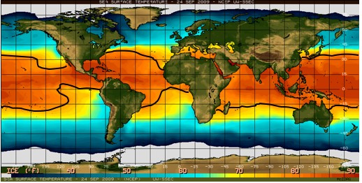
In Hurricane Genesis: Birth of a Hurricane, the formation of tropical depressions in the Earth’s atmosphere is discussed. The formation of a tropical depression can lead to the birth of a hurricane. In this section, the maturation of a tropical depression into a hurricane and the survival of that hurricane are reviewed. In Hurricane Decay: Demise of a Hurricane, the causes of hurricane decay are described. A Hurricane’s Energy Source: The Ocean Development of a tropical depression into a mature hurricane requires heat energy from the ocean surface. For this reason, hurricanes do not usually develop over land or outside of the warm tropical oceans where the sea surface temperature (SST) is colder than ~26.5°C (~80°F). In the image below, the orange areas indicate where the sea surface temperature was at least 26.5°C (79.7°F) on September 24, 2009. In the North Atlantic Ocean, this area extends westward along a narrow swath from the west coast of Africa to the northern tip of South America. At the western end of this swath, the warm water also extends northward through the Caribbean Sea and into both the Gulf of Mexico and Sargasso Sea (off the east coast of Florida). The size of the warm water area changes with the seasons. In the North Atlantic Ocean, September generally has the largest area of the warmest water; earlier or later in the year, the area of warm sea surface temperatures is smaller. It is not a coincidence that the peak of the Atlantic hurricane season also occurs in September.
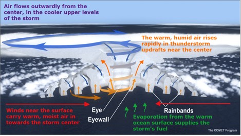
Heat is transferred from the ocean to the atmosphere when water at the ocean’s surface evaporates to become water vapor. This causes the ocean to cool slightly. The heat transferred to the atmosphere from the ocean is stored in the water vapor as latent heat. To understand why evaporation of ocean water transfers heat from the ocean to the atmosphere, please see Basic Science. It is important to note, however, that underneath a hurricane, other processes within the ocean usually cause the sea surface to cool much more than evaporation does, as described in Interaction between a Hurricane and the Ocean. Energy Cycle: A Hurricane’s Secondary Circulation In the lower troposphere, air parcels carry heat energy obtained from the ocean. These air parcels spiral inward towards the center of the developing hurricane. Once an air parcel reaches the hurricane’s eyewall, it turns upward and rises due to a process called convection. The added heat from the ocean causes the air rising in the eyewall to be warmer than the surrounding environment, allowing it to continue to rise. Once the air parcel reaches the tropopause, the boundary between the troposphere and the stratosphere, it begins to spiral outward. As the air parcel spirals outward, it loses heat to outer space by long wave radiation. At some point far away from the center of the hurricane, the cooled air parcel begins to sink back towards the lower troposphere. Then, this cycle, which is known as a hurricane’s secondary circulation, is complete.
Since the conversion of heat energy to mechanical energy drives the hurricane’s secondary circulation, a hurricane can be treated as a heat engine. For the engine to continue working, air must flow into the system (the hurricane) at a higher temperature than it exits the system. As long as the air parcels can rise in the eyewall and then spiral outward at the tropopause faster than other air parcels can spiral inward towards the eyewall in the lower troposphere, the central pressure in the developing hurricane will fall. A falling central pressure is one way to measure how much a hurricane is intensifying. Increasing winds increase the transfer of heat from the ocean, creating a positive feedback. When the central pressure falls, air parcels begin to spiral inward towards the eyewall faster to fill the vacuum. If the air parcels spiral inward faster, then the maximum wind speed will increase. Increasing maximum wind speed is another way to measure how much a hurricane is intensifying (more intense hurricanes have faster maximum sustained wind s). Eventually, a hurricane may reach a near steady state (in theory), where the heat energy coming in from the ocean is balanced by the energy lost to frictional dissipation in the atmosphere. In this “quasi-steady state”, neither the hurricane’s central pressure nor its maximum wind speed changes much over time. In reality, though, a hurricane rarely remains in quasi-steady state for an extended period of time because changes in the surrounding atmosphere, the underlying ocean, or the hurricane’s internal structure can cause the hurricane’s intensity to change. |
 |
Please address comments and questions to hurricane@etal.uri.edu