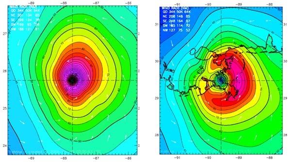
As a hurricane approaches land, portions of the outer circulation start to include air originating over land. This land-based air is cooler and drier than the air in the hurricane that originated over water. This portion of the circulation over land is initially efficient in transporting the cooler, drier air towards the center of the hurricane because of the increased friction over land relative to over the ocean (see Primary Circulation). In the right-front quadrant of the hurricane, the variation in inflow can help create areas of strong air convergence in the lower troposphere. These convergence zones provide a favorable environment for outer rainbands that are capable of severe weather, including tornadoes, well before the storm center crosses the coast. In the hours prior to landfall, hurricanes typically pass over cooler ocean shelf water, which can limit hurricane intensity relative to warmer ocean water further off the coast (see Hurricane Development: From Birth to Maturity). This temperature difference between ocean shelf water and ocean water further off the coast may be even larger below the sea surface than at the sea surface, which may further limit hurricane intensity near the coast but prior to landfall (see Interaction Between a Hurricane and the Ocean). Atmospheric fronts and regions of strong vertical wind shear are often present near the coast. When a coastal front interacts with a hurricane prior to landfall, cooler, drier air may be transported into one side of the hurricane, leading to weakening. Enhanced vertical wind shear also typically weakens a hurricane. When one or more of the processes described above leads to weakening of a hurricane in the hours before landfall, the hurricane’s wind field is often observed to expand in size. This wind field expansion can be explained by a physical law called conservation of angular momentum. Sometimes, outer portions of the hurricane may experience increased wind speeds even though the maximum wind speed is decreasing, as in the case of Hurricane Katrina (2005). While the intensity reduction may be welcomed from the standpoint of anticipated wind damage at landfall, the wind field expansion may be equally or more dangerous because of increased risks from storm surge and waves. Wind field expansion increases the fetch, defined as the distance the wind travels over the sea surface, which allows increased wave development that can contribute to both storm surge and wave damage.
There are notable exceptions to the often-observed weakening of hurricanes in the hours prior to landfall, particularly in mid season and at lower latitudes when a hurricane can intensify while passing over a warm ocean feature that may be relatively close to land without the negative influence of strong vertical wind shear (e.g. Hurricanes Carla 1961, Celia 1971, Andrew 1992, and Katrina 2005). Such hurricanes may also undergo eyewall replacement cycles that can magnify their impacts if landfall occurs during the intensification part of the cycle. During landfall, as the eyewall begins to cross the coast, differences between the air friction caused by the ocean and the land cause the wind field to become less symmetric around the hurricane’s center, and lead to areas of enhanced air convergence and divergence in certain regions of the hurricane. The regions can affect the distribution of convection and rainfall, but primarily they contribute to a large variation in wind speed and gustiness over a small area (land causes the wind to be more gusty). As air in the hurricane crosses the coast from ocean to land, the air flow responds to the new underlying surface with about 80% of the adjustment occurring a few hundred meters inland but the remaining 20% taking tens of kilometers to occur. The gustiness over the ocean is on the order of 10% but may increase to 20-30% or more over land (where there is increased friction), depending on the roughness of the land surface. Therefore, steady winds over land may be lower than over the ocean due to higher roughness, but the winds over land may have higher gusts.. Flow over complex terrain is much more complicated, with localized wind maxima occurring on exposed hillsides where air flow may accelerate over bluff shaped hilltops to more than double the wind speed of the surrounding air. By the time the hurricane’s center crosses the coast, the inflowing wind speed has increased to over half the primary circulation’s wind speed, so drier (and often cooler) air is fueling over half the eyewall, resulting in rapid weakening. The expansion of the wind field continues, but now much of the outer part of the hurricane’s circulation is experiencing enhanced roughness over land, so the size of the tropical storm and hurricane strength wind fields begin to decrease and eventually dissipate. |


