
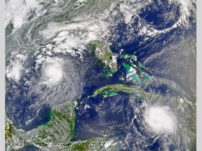
Hurricane Charley was the first of four hurricanes to infamously impact Florida within six weeks during the highly active 2004 hurricane season. Charley developed from a tropical wave that moved off the coast of Africa on August 4, 2004. The wave moved rapidly across the Atlantic Ocean, and developed steadily. On 9 August while located 185 km (115 mi) south-southeast of Barbados, the system strengthened to become a tropical depression. It continued into the Caribbean Sea and became Tropical Storm Charley the next day. A strong ridge of high pressure caused the storm to turn northwest as it became Hurricane Charley on 11 August, about 145 km (90 mi) south of Kingston, Jamaica. The hurricane intensified to Category 2 strength after passing 24 km (15 mi) northeast of Grand Cayman Island. The hurricane further strengthened to Category 3 status just before making landfall over western Cuba early on 13 August with sustained winds of 193 km/h (120 mph). The hurricane crossed the island, passing 19 km (12 mi) west of downtown Havana.
After exiting Cuba, Hurricane Charley turned north northwestward, accelerated, and rapidly intensified. The storm went from a hurricane with winds of 177 km/h (110 mph) to one with 233 km/h (145 mph) winds in just 3 hours. Charley then turned more towards the northeast and continued to strengthen, reaching Category 4 status with winds of 241 km/h (150 mph). The hurricane made a second landfall at Category 4 strength on Captiva Island near Cayo Costa, FL midday on 13 August. The eye struck Punta Gorda, FL an hour later with devastating results. The diameter of the eyewall had shrunk to 9.6 km (6 mi) wide, however, and this helped to limit the most severe damage to a 16 kilometer-wide (10 mi) swath. Hurricane Charley tracked across Florida along the Peace River corridor and moved directly over Orlando around 1:30 AM on 14 August with winds over 137 km/h (85 mph). The hurricane exited Florida just two hours later near Daytona Beach and continued to move quickly to the north-northeast (it only took ~ 7 hours for Charley to cross the entire Florida peninsula). Charley made another landfall near Cape Romain, SC early in the afternoon of 14 August with winds of 129 km/h (80 mph). The hurricane moved offshore and then came ashore again a few hours later near North Myrtle Beach, SC with winds of 121 km/h (75 mph). The storm then began interacting with an upper level trough and was downgraded to a tropical storm. It moved back into the Atlantic Ocean near Virginia Beach, VA on 15 August and became extratropical. Charley’s remnants became fully absorbed by a trough off the coast of southeastern Massachusetts later that day. As Hurricane Charley passed Jamaica, strong winds downed power lines and trees. This, combined with heavy rains, caused a moderate amount of damage to the island’s agricultural industry ($1.44 million 2004 USD), amounting to a total of $4.1 million (2004 USD) in losses on the island. In Cuba, Charley’s 193 km/h (120 mph) winds downed almost 1,500 power lines and 28 high tension wire towers, leaving half of the Havana Province and all of Pinar del Rio Province without power for at least 11 days. The nation’s agriculture industry was critically hit with the loss of 15,000 tons of grapefruit and destruction of 57,000 acres of fruit trees. About 95% of sugarcane, banana and bean crops were also affected. Agricultural losses compromised the majority of the $923 million (2004 USD) in damages in Cuba. The area that received the most destruction due to Hurricane Charley, however, was Florida. In the Florida peninsula alone, $14.6 billion in property damage occurred. Areas in the southwestern part of the state were exposed to strong Category 4 strength winds in the hurricane’s eyewall. Eighty percent of the buildings in the southwest county of Charlotte were destroyed and a 2.4 m (8 ft) storm surge occurred in Lee County. One third of all the schools in Charlotte County were demolished, and all 59 schools in Osceola County were damaged. Many public schools along the path of the hurricane remained closed for two weeks due to damage or even complete destruction of the school buildings. Punta Gorda, which received a direct hit from the eye of the hurricane, was completely leveled. Six schools and 6 fire stations were ruined. In the city of about 16,000 residents, 11,000 homes were destroyed, half of which were mobile homes (90% of which were not up to post-Andrew code. Throughout the Atlantic basin, hurricane Charley caused $16.3 billion (2004 USD) in damage and was responsible for 15 deaths. Total damage from Hurricane Charley in the United States was estimated to be $15.4 billion (2004 USD) with damages of $25 million in NC, $20 Million in SC, and the rest occurring in Florida. At the time, before Hurricanes Katrina, Wilma and Ike, this made Charley the second costliest hurricane in U.S. History. Fast Facts:
Sources:
Blake, Eric S. et al. “Tropical Cyclone Report: Hurricane Charley 9-14 August 2004.” National Hurricane Center. 18 Oct. 2004. Web. Franklin, James L. et al. “Annual Summary: Atlantic Hurricane Season of 2004.” Monthly Weather Review. 134 (2006). Pp 988-995. Web. “Hurricane Charley.” Wikipedia. 2009. Web. “Effects of Hurricane Charley in Jamaica.” Wikipedia. 2009. Web. “Effects of Hurricane Charley in South Carolina.” Wikipedia. 2009. Web. “Effects of Hurricane Charley in North Carolina.” Wikipedia. 2009. Web. Emanuel, Kerry A. Divine Wind. Oxford: Oxford University Press, 2005. Pp. 260. Sallenger, A.H., Stockdon, H.F., Fauver, L., Hansen, M., Thompson, D., Wright, C.W., and Lillcrop, J. 2006. Hurricanes 2004: An Overview of Their Characteristics and Coastal Change. Estuaries and Coasts. 29 (6A): 880–888. |
 |
Please address comments and questions to hurricane@etal.uri.edu