
Basic Statistics
Dates
Maximum wind speed Minimum pressure Deaths Damage Landfall
August 24- September 10, 2004
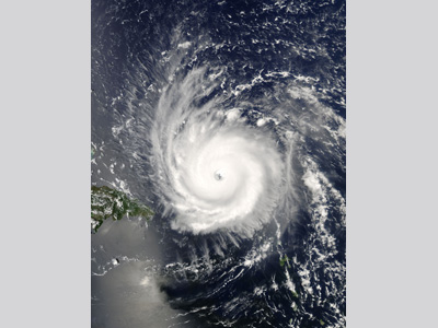
225 km/h (140 mph) 935 mb 7 directly related $12 billion US Hutchinson Island, FL Of the 9 tropical cyclones that reached hurricane status in 2004, 5 made landfall, 4 of which battered the state of Florida. Hurricane Frances was the second of these four hurricanes, striking Florida just weeks after Hurricane Charley made landfall along the southwestern part of the state. Frances originated from a strong tropical wave that moved off the African coast on August 21, 2004. The system remained disorganized until it was upgraded to a tropical depression on 24 August and a tropical storm on 25 August. Tropical Storm Frances then tracked to the west-northwest on 26 August, rapidly intensifying to a hurricane later that day (making Frances the 4th hurricane of the 2004 season). By 28 August, Hurricane Frances had reached Category 4 status with winds of 217 km/h (135 mph). The hurricane then turned westward and weakened (winds 185 km/h /115 mph) due to an eyewall replacement cycle. Frances regained Category 4 strength late on 30 August, tracking into the Bahamas on 1 September with maximum winds near 225 km/h (140 mph). Due to another series of concentric eyewall cycles and moderate, westerly wind shear, Frances weakened over the next two days. The hurricane passed over the central Bahamas on 2-3 September with winds of 185-201 km/h (115-125 mph) (Category 3) and the northwestern Bahamas on 3-4 September with winds of 157-167 km/h (98-104 mph) (Category 2).
Hurricane Frances moved slowly, between 8 km/h (5 mph) and 16 km/h (10 mph), as it crossed the warm Gulf Stream between the Bahamas and Florida. Because of Frances' large eye, which was roughly 130 km (80 mi) across, and its slow forward motion, the center of the hurricane’s circulation remained off the Florida coast for about 24 hours, battering the shoreline. The hurricane finally made landfall as a Category 2 storm at Hutchinson Island, FL, early on 5 September with winds of 169 km/h (105 mph) and a minimum central pressure of 960 mb (hPa). Frances weakened gradually as it continued its slow track across the state, becoming a tropical storm just before emerging into the northeastern Gulf of Mexico, just north of Tampa, FL, early on 6 September. The tropical storm did not restrengthen over the open waters of the Gulf and made a second landfall later that day on the Florida Panhandle with maximum sustained winds of 105 km/h (65 mph). On 7 September, the storm was downgraded to a tropical depression over eastern Alabama and became extratropical over West Virginia by 9 September. The system finally dissipated over the Gulf of St. Lawrence on 10 September. Frances brought hurricane conditions to much of the central and northwestern Bahamas, southeastern Florida, and the adjacent Atlantic. Frances was the first hurricane since 1866 to impact the entire archipelago of the Bahamas. The southeast, central, and northwestern islands were significantly impacted- industry insured losses in the Bahamas were around $300 million (2004 USD.). Damage and losses due to Hurricane Frances’ winds, rainfall, and storm surge caused President George W. Bush to declare all of Florida, the southern two-thirds of Georgia, the northeast section of South Carolina and 34 counties in North Carolina federal disaster areas following the storm. Wind damage to citrus groves led to a near total loss near the coast of east-central Florida between West Palm Beach and Melbourne. Between Hurricane Charley and Frances, citrus losses totaled $2 billion (2004 USD dollars); Florida is the second largest producer of oranges in the world. Hurricane-force winds also caused $100 million worth of damage to the space and military facilities around Cape Canaveral, FL, most notably to the Vehicle Assembly Building at Kennedy Space Center where over a thousand 4X10 foot aluminum panels were ripped off. Unlike Hurricane Charley, which quickly crossed the Florida peninsula in about 7 hours, Hurricane Frances crawled across the state. As the system moved slowly to the west-northwestward, heavy rains flooded grounds already saturated by Hurricane Hurricane Charley. The heaviest rains fell in north-central Florida including Citrus, Marion, Levy, and Alachua counties. In coastal Hernando County, the town of Chassahowitzka saw over 380 mm (15 in) of rainfall and Tampa received around 200 mm (8 in). South Carolina received a large amount of rain as well with Lineville Falls reporting 460 mm (18.1 in) and many other locations reporting accumulations over 250 mm (10 in). The Appalachians Mountains in North Carolina actually experienced the most rainfall from the hurricane. Mount Mitchell, North Carolina recorded a total accumulation of 599 mm (23.6 in). Frances produced notable storm surges along both the Atlantic and Gulf coasts of Florida. The highest measured storm surge was 1.8 m (5.9 ft) above mean sea level on the Florida east coast at the St. Lucie Lock. The National Weather Service (NWS) Melbourne Weather Forecast Office estimated storm surge to be 2.4 m (8 ft) near Vero Beach and 1.8 m (6 ft) around Cocoa Beach. Lesser storm surge values were estimated elsewhere along the Florida east coast, while storm surges of 0.3-0.6 meters (1-2 ft) above normal tide levels were reported as far north as Georgia. Overall, Hurricane Frances caused an estimated $12 billion (2004 USD) in damage placing it among the top ten costliest Atlantic hurricanes in history. Fast Facts:
Sources:
Sallenger, A.H., Stockdon, H.F., Fauver, L., Hansen, M., Thompson, D., Wright, C.W., and Lillcrop, J. 2006. Hurricanes 2004: An Overview of Their Characteristics and Coastal Change. Estuaries and Coasts. 29 (6A): 880–888. “Hurricane Frances.” Wikipedia. 2009. Web. http://en.wikipedia.org/wiki/Hurricane_Frances Beven II, John L. “Tropical Cyclone Report: Hurricane Frances 25 August - 8 September 2004.” National Hurricane Center. 2005. Web. Franklin, James L. et al. “Annual Summary: Atlantic Hurricane Season of 2004.” Monthly Weather Review 134 (2006). Pp. 995-1002. Web. “Hurricane Frances.” National Weather Service Weather Forecast Office, Melbourne, FL. 2009. Web. “NOAA Reports Record Number of Tornadoes in 2004.” NOAA Magazine. Online. Coastal Change Hazards: Hurricanes and Extreme Storms, Hurricane Frances. USGS St. Petersburg Science Center NASA’s Hurricane Portal- Hurricane Frances USGS: Floods in Southwest-Central Florida from Hurricane Frances, |
 |
Please address comments and questions to hurricane@etal.uri.edu