 |
National Hurricane Center Forecast and Warning Products |
|
The National Hurricane Center (NHC), in coordination with one or more National Weather Service (NWS) Weather Forecast Offices (WFOs), issues a hurricane watch for specific coastal areas when hurricane force winds (sustained winds of 119.1 km/h [74 mph] or higher) are possible within 48 hours. This hurricane watch is upgraded to a hurricane warning when hurricane force winds are expected within 36 hours or less. A hurricane warning can remain in effect when dangerously high water or a combination of dangerously high water and exceptionally high waves continue, even though winds may be less than hurricane force. If only tropical storm force winds are expected (sustained winds of 62.8- 117.5 km/h [39-73 mph]), then a tropical storm watch or tropical storm warning will be issued for that area.
In addition to watches and warnings, NHC issues a variety of text and graphical products designed to inform the public of forecasted hurricane threats. A complete description of all of these products can be found in the National Hurricane Center Product Description Document: A User’s Guide to Hurricane Products.
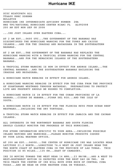 Advisory Advisory number 28a for Hurricane Ike." border="0" hspace="0" vspace="0" align='absmiddle'> Tropical Cyclone Public Advisory number 28a for Hurricane Ike, issued by the National Hurricane Center (NHC) at 2:00am EDT on September 8, 2008. Please see www.nhc.noaa.gov/archive/2008/al09/al092008.public_a.028.shtml for the full advisory. |
The most important of the NHC’s text products is the Tropical Cyclone Public Advisory. This public advisory provides critical hurricane watch (or tropical storm) watch, hurricane warning (or tropical storm) warning, and forecast information, and it is intended for distribution to the general public to protect life and property. The advisories are issued every six hours at 0300, 0900, 1500, and 2100 UTC (11pm, 5 am, 11 am, and 5pm Eastern Daylight Time), although special forecasts and/or advisories may be issued at any time. Intermediate public advisories are issued every 2-3 hours once a watch or warning is in place. A Tropical Cyclone Public Advisory includes:
- a list of all current coastal watches and warnings for a particular hurricane
- the hurricane’s current position in latitude and longitude coordinates
- the hurricane’s distance from a well-known reference point
- the hurricane’s current direction and speed of motion
- the hurricane’s maximum sustained wind speed and direction
- the hurricane’s estimated or measured minimum central pressure
- a general description of the hurricane’s predicted track and intensity over the next 1-2 days
- information on potential storm tides (astronomical tide plus storm surge), rainfall, or tornadoes associated with the hurricane (when warnings are in effect)
- relevant weather observations associated with the hurricane
Another important text product distributed by the NHC is the Tropical Cyclone Discussion. This discussion is where an NHC forecaster explains how he or she arrived at a particular forecast, and it typically includes:
- a discussion of the observations justifying the analyzed intensity of the hurricane
- a description of the environmental factors expected to influence the hurricane’s future track and intensity
- a description of the hurricane forecast models used as guidance
- the forecaster’s confidence in his or her official forecast
- a discussion of possible alternate scenarios
- a highlight of unusual hazards
- a table of forecast hurricane positions and intensities for the next 5 days
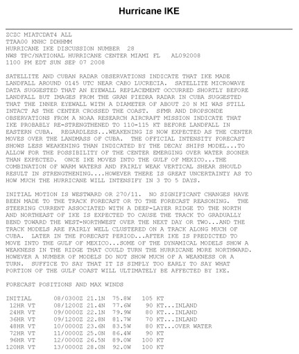 Tropical Cyclone Discussion number 28 for Hurricane Ike, issued by the National Hurricane Center (NHC) 11:00pm EDT on September 7, 2008. Please see www.nhc.noaa.gov/archive/2008/al09/al092008.discus.028.shtml for the full advisory. |
|
A third text product distributed by the NHC is the Tropical Cyclone Surface Wind Speed Probabilities. This product provides probabilistic information about the forecasted intensity of a tropical cyclone. In other words, this product provides the likelihood that the tropical cyclone will generate a certain wind speed at a certain location. In addition to the text product, various graphical products are created that display some of the information in the text product. An example of both the text product and one of the graphical products are given below.
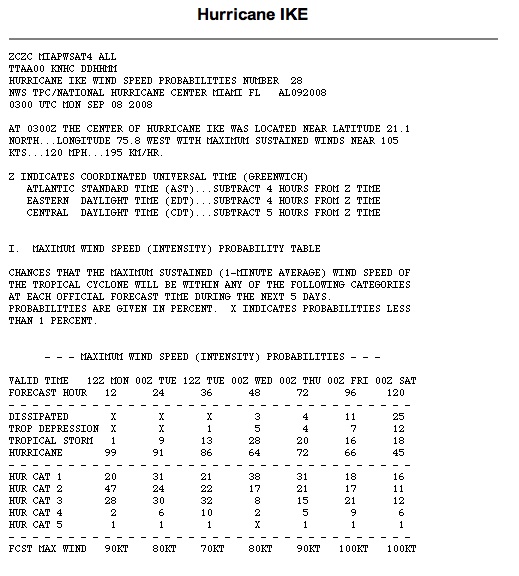 Tropical Cyclone Surface Wind Speed Probabilities number 28 for Hurricane Ike, issued by the National Hurricane Center (NHC) 0300 UTC on September 8, 2008. Please see www.nhc.noaa.gov/archive/2008/al09/al092008.wndprb.028.shtml for the full text product. |
|
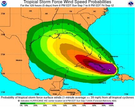 Tropical Cyclone Surface Wind Speed Probability Graphic for Hurricane Ike (2008). This graphic depicts NHC’s forecasted probability (expressed as a percentage) that the sustained (1-minute average) wind speed will meet or exceed minimum tropical storm strength (62.8 km/h [39 mph]) at a certain location during a certain time interval. Image credit: NOAA/NHC. |
|
Perhaps the most recognizable and most widely distributed graphical product is the Tropical Cyclone Track Forecast Cone and Watch/Warning Graphic. This graphic depicts the latest position of the tracked tropical cyclone as well as the NHC’s forecast track (and the familiar cone of surrounding it) for that tropical system. Coastal areas under a hurricane or tropical storm watch and/or warning are also shown.
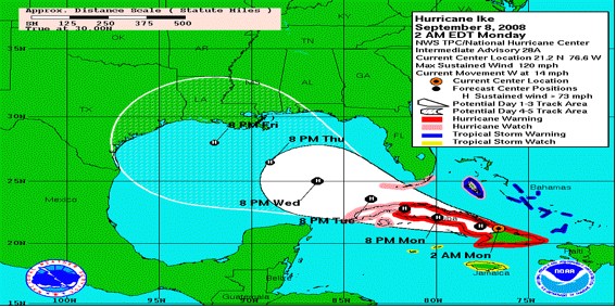 Tropical Cyclone Track Forecast Cone and Watch/Warning Graphic for Hurricane Ike (2008). This graphic depicts the NHC forecast track of the center of a hurricane along with an approximate representation of associated coastal areas under a hurricane warning (red), hurricane watch (pink), tropical storm warning (blue), and tropical storm watch (yellow). The orange circle indicates the current position of the center of the tropical cyclone. The black dots show the NHC forecast position of the center at the times indicated. The letter inside the dot indicates the forecast strength of the cyclone category: (D)epression, (S)torm, (H)urricane, (M)ajor hurricane, or remnant (L)ow. Systems forecast to be extratropical are be indicated by white dots (with black letters indicating intensity). The cone represents the probable track of the center of a tropical cyclone, and is formed by enclosing the area swept out by a set of circles (not shown) along the forecast track (at 12, 24, 36 hours, etc). The size of each circle is set so that two-thirds of historical official forecast errors over a 5-year sample fall within the circle. Image credit: NOAA/NHC. |
|
Another graphical product that is useful for visualizing all of the current and potentially-developing tropical cyclones in a given ocean basin is NHC’s Graphical Tropical Weather Outlook. This interactive graphic depicts significant areas of disturbed weather and their potential for development into a tropical depression or tropical storm (and then perhaps a hurricane) during a 48-hour period. The Outlook also shows the locations of any active tropical depressions, tropical storms, and hurricanes. During the Atlantic hurricane season, an RSS feed located on this website’s homepage will provide a direct link to NHC’s latest Graphical Tropical Weather Outlook.
 Graphical Tropical Weather Outlook from September 11, 2009. This graphic depicts significant areas of disturbed weather and their potential for development of a tropical cyclone during the next 48 hours. The Outlook also shows the locations of any active tropical depressions (“L”-symbol), tropical storms (tropical storm symbol with hollow center), and hurricanes (hurricane symbol with filled center). Areas of disturbed weather on the graphic are circled and numbered, with text discussions for each disturbance given beneath the graphic. The potential for tropical cyclone formation for each disturbance within the next 48 hours is indicated by the color of the enclosing circle: yellow indicates a low probability of development (<30%), orange indicates medium likelihood (30-50%), and red indicates a high likelihood of development (>50%). The graphic is interactive; users can mouse over tropical cyclones or disturbances in the graphic and pop-up windows will appear with tropical cyclone advisory information or the text Outlook discussion for that disturbance. Clicking on a tropical depression, tropical storm, or hurricane symbol will take the user to a new web location that contains all advisories and products for that particular tropical cyclone. Image credit: NOAA/NHC. |
|
Dissemination of hurricane forecasts and warnings
Hurricane forecasts and warnings issued by the NHC or local NWS WFOs are publicly available through a variety of media outlets. These media outlets include, but are not limited to:
- NOAA Weather Radio: http://www.weather.gov/nwr/
- National Hurricane Center webpage: http://hurricanes.gov
- National Weather Service webpage: http://weather.gov
- Local TV or radio stations
- Private TV or web-based media outlets, such as The Weather Channel or Weather Underground
Forecasts and warnings are coordinated between the NHC and local NWS WFOs to provide consistency, which is critical during significant weather episodes. Local emergency managers are also provided with the latest forecasts and warnings so they can take appropriate action to help protect the public, such as issuing evacuations (see Hurricane Preparation, Response, Recovery and Risk Mitigation). Once hurricane season begins, it is important for anyone at risk of being impacted by a hurricane to pay attention to these local weather updates and advisories on the television and radio as well as the NHC products available online.
References
Additional Links on HSS
|
|

