
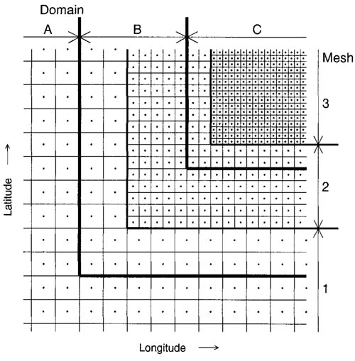
Similar to a hurricane forecast model, a hurricane research model is an objective tool, based on mathematical equations, that is designed to simulate the behavior of a tropical cyclone. Hurricane research models, however, are not used to make a real-time operational forecast, so they can use higher resolution and/or include more complicated (or simpler) physics than a hurricane forecast model. In the United States, some of the leading dynamical hurricane research models in continuous development are the Hurricane Weather Research and Forecasting Experimental Modeling System (HWRFx), the Advanced Research Hurricane Weather Research and Forecasting Model (AHW), the Coupled Ocean/Atmosphere Mesoscale Prediction System – Tropical Cyclone (COAMPS-TC), the High-Resolution Atmospheric Model (HiRAM), the Flow-Following Finite Volume Icosahedral Model (FIM), and the Coupled Hurricane Intensity Prediction System (CHIPS). These research models eventually may be used as hurricane forecast models or at least contribute to improving existing hurricane forecast models. Like the regional dynamical hurricane forecast models, the three regional dynamical hurricane research models (HWRFx, AHW, and COAMPS-TC) have a multiple-nest grid configuration.
Hurricane Weather Research and Forecasting Experimental Modeling System (HWRFx)
HWRFx, developed at NOAA’s Atlantic Oceanographic and Meteorological Laboratory (AOML) and NOAA’s National Centers for Environmental Prediction (NCEP) Environmental Modeling Center (EMC), is a variant of NOAA’s operational HWRF forecast model, which forecasts hurricane track and intensity. HWRFx has a higher resolution than HWRF, as well as different physical parameterizations of various atmospheric processes. The operational HWRF currently has a two-nest grid configuration, where the outer grid has 27-km horizontal grid spacing and the inner grid has 9-km horizontal grid spacing. By contrast, HWRFx has a two-nest configuration with 9-km horizontal grid spacing on the outer grid and 3-km horizontal grid spacing on the inner grid. Other configurations have also been developed for HWRFx that include 1-km horizontal grid spacing on the inner grid or a three-nest grid configuration with 27-km, 9-km, and 3-km horizontal grid spacing on the outer, middle, and inner grids, respectively. These high-resolution configurations show promise for increasing the accuracy of model-simulated track, intensity, and in particular, storm structure. In fact, the three-nest 27/9/3-km HWRFx configuration has recently been merged with the operational HWRF hurricane forecast model in preparation for eventual operational implementation of the three-nest configuration. Advanced Research Hurricane Weather Research and Forecasting Model (AHW)
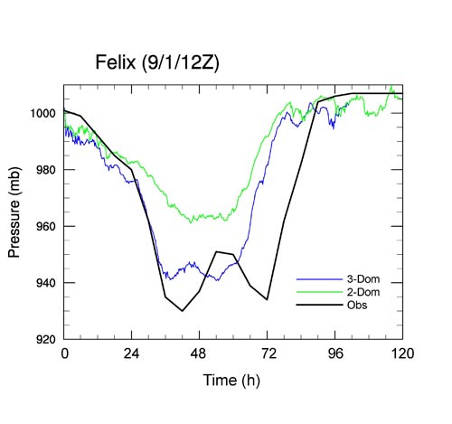
AHW, developed primarily at the National Center for Atmospheric Research (NCAR) in collaboration with the State University of New York at Albany, is a subset of the Weather Research and Forecasting (WRF) atmospheric model that is tailored specifically for simulating hurricanes. Unlike HWRF and HWRFx, which use the so-called Nonhydorstatic Mesoscale Model (NMM) dynamical core, AHW uses the so-called Advanced Research WRF (ARW) dynamical core and physics. AHW is coupled to a simple mixed-layer ocean model. While the resolution and grid nesting options in AHW are flexible, NCAR currently runs real-time AHW predictions of Atlantic hurricanes using two different three-nest configurations. The first configuration has 36-km, 12-km, and 4-km horizontal grid spacing on the outer, middle, and inner grids, respectively. The second configuration has 12-km, 4-km, and 1.33-km horizontal grid spacing on the outer, middle, and inner grids, respectively. For some hurricanes (Ike (2008), Earl (2010), and Igor (2010), for example), both AHW grid configurations capture the storm's rapid intensification phase, but for other hurricanes (Katrina (2005), Rita (2005), and Felix (2007), for example), only the configuration with higher resolution (1.33-km inner grid spacing) captures the storm's rapid intensification phase.
Coupled Ocean/Atmosphere Mesoscale Prediction System – Tropical Cyclone (COAMPS-TC)
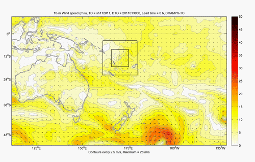
COAMPS-TC, developed by the U.S. Naval Research Laboratory (NRL) Marine Meteorology Division, is a new version of the Coupled Ocean/Atmosphere Mesoscale Prediction System (COAMPS®) that is tailored specifically for predicting tropical cyclones worldwide (including, but not limited to, Atlantic hurricanes). COAMPS-TC is capable of an arbitrary number of grid meshes and has been tested with horizontal grid spacing as fine as 1 km. COAMPS-TC features options for fully interactive air-ocean-wave coupling with the NRL Coastal Ocean Model (NCOM) and the Simulating WAves Nearshore (SWAN) and WaveWatch III wave models. Real-time applications typically consist of a three-nest configuration with 45-km, 15-km, and 5-km horizontal grid spacing on the outer, middle, and inner grids, respectively. In addition to numerous retrospective runs, COAMPS-TC has been run experimentally in real-time to evaluate its performance since 2008.
COAMPS® is a trademark of the Naval Research Laboratory. High-Resolution Atmospheric Model (HiRAM)
HiRAM, developed at NOAA’s Geophysical Fluid Dynamics Laboratory (GFDL), is a global model designed for both weather predictions and climate simulations. Recently, when run with 25-km horizontal grid spacing, HiRAM was shown to accurately predict the interannual variability of seasonal hurricane activity in the Atlantic basin. Unlike HWRFx, AHW, and COAMPS-TC, HiRAM is not intended to accurately predict individual hurricane tracks and intensity in its current configuration, but when computational resources become available to further increase HiRAM’s resolution, such predictions may be possible. Flow-Following Finite Volume Icosahedral Model (FIM)
FIM, developed at NOAA’s Earth Systems Research Laboratory (ESRL), is a global model designed for weather prediction. The unique aspect of FIM is that the grid points do not form squares or rectangles. Instead, the grid is composed of hexagons and pentagons. Two configurations of FIM with different initial conditions are currently used experimentally for hurricane genesis prediction. Both configurations have 30 km grid spacing. More information about FIM, including real-time forecasts, when available, can be found on the NOAA/ESRL’s FIM Global Model webpage. Coupled Hurricane Intensity Prediction System (CHIPS)
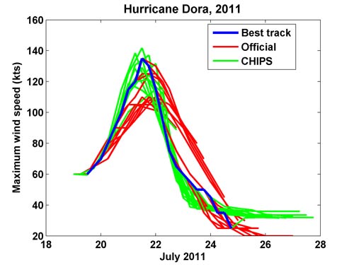
CHIPS was developed at the Massachusetts Institute of Technology (MIT) as a very simple research model to help students understand the physics of tropical cyclones and how these physics act to control tropical cyclone intensity. CHIPS was later adapted to predict the intensity of real tropical cyclones and is currently used as an aid to forecasting storm winds. The model assumes that storms are circular and calculates storm physics in a coordinate system in which angular momentum serves as the radial coordinate. This coordinate system allows the model to achieve very high spatial resolution in the critical eyewall region of the storm, sacrificing resolution in the storm’s outer region. The atmospheric model is coupled to an equally simple ocean model that includes only the physics of upper-ocean mixing. The circular geometry of the model prevents it from explicitly simulating the effects of vertical wind shear, which must be represented indirectly. The simplicity of the model allows it to simulate a typical tropical cyclone in about 15 seconds on an ordinary laptop computer, so it can be run many times to produce an ensemble of intensity forecasts. Forecasts using CHIPS and other models are posted every 6 hours at MIT’s Tropical Cyclone Intensity and Track Forecasts webpage.
Other Hurricane Research Models and Model Configurations
To understand the impact of various physical processes on tropical cyclone track and/or intensity, researchers at some universities and meteorological institutions around the world use their own configurations of hurricane research models, such as the Weather Research and Forecasting (WRF) atmospheric model and/or its predecessor, the Pennsylvania State University–National Center for Atmospheric Research (PSU–NCAR) Mesoscale Model (MM5). For example, scientists in Taiwan have used a version of the MM5 model to simulate the track, intensity, precipitation, and other features of landfalling typhoons that have significantly impacted the area. Due to its location in the northwest Pacific Ocean, Taiwan is impacted frequently by landfalling typhoons. During 1958–2005, Taiwan was struck by 161 typhoons, with 86 of them making landfall on the island. Since Taiwan has a complex terrain (approximately 70% of the total land area consists of mountains), one key focus of the Taiwanese research was to use the MM5 model to investigate the impact of steep topography (mountains) on structural changes and rainfall generation in landfalling typhoons. |
 |
Please address comments and questions to hurricane@etal.uri.edu