 |
NASA Aircraft |
|
 NASA DC-8 aircraft. Image courtesy of NASA's Dryden Flight Research Center. |
While the United States Air Force and the National Oceanographic and Atmospheric Administration (NOAA) perform operational surveillance of hurricanes, the National Aeronautics and Space Administration (NASA) also uses some of its aircraft fleet for more focused research field campaigns. NASA’s field campaigns are essential for observing and measuring Earth system phenomena and validating computer models that simulate Earth systems. Projects related to tropical cyclone observations include the Convection and Moisture Experiments (CAMEX-3, CAMEX-4 in 1998 and 2001, respectively), , the Tropical Cloud Systems and Processes (TCSP) experiment in 2005, the NASA African Monsoon Multidisciplinary Analyses (NAMMA) experiment in 2006, and the Genesis and Rapid Intensification Processes (GRIP) experiment in 2010. During these field campaigns, NASA uses a suite of advanced remote sensors and in-situ instruments: environmental properties are measured by sondes, lidars, and sounders, internal structure is measured by precipitation radars, microwave radiometers, and sounders, and microphysical properties are measured by cloud and precipitation probes and aerosol detectors.
The two aircraft most frequently used in NASA field campaigns are the NASA DC-8 and ER-2 aircrafts. The NASA DC-8 is similar to a typical passenger aircraft, but instead of row upon row of seats, the cabin has been set up to house large instrument packages with more limited seating for instrument investigators and mission scientists. The jetliner has been transformed into an airborne science laboratory, well suited for instruments that need more hands-on control during flight. The DC-8 flies at a range of altitudes from the boundary layer up to about 40,000 ft, and it can fly up to 10 hours at a time. It is also capable of penetrating a hurricane’s eyewall, making it ideal for collecting in-situ cloud microphysics data in the ice-phase regions of storms.
 NASA ER-2 aircraft. Image courtesy of NASA's Dryden Flight Research Center. |
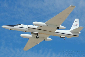
The NASA ER-2 is a high-altitude flying aircraft (~65,000 ft) with a single pilot and no other onboard crew, meaning that all instruments must work on their own over the typical 8-10 hour duration of the flight. The ER-2 is well suited for instruments that need to be above the tops of clouds to obtain optimal measurements and a satellite-like view of the atmosphere. Due to its high-altitude capabilities, the ER-2 has been an invaluable tool for studying tropical cyclone development, tracking, intensification, and landfall impacts. ER-2 aircraft have flown over several hurricanes, including major Hurricanes Emily (2005) and Dennis (2005), collecting detailed information on the hurricanes’ vertical structure. In addition to supporting tropical cyclone research, ER-2 aircraft are frequently used to provide imagery for natural disaster assessments (such as the aftermath of Hurricane Iniki, which struck Hawaii in 1992).
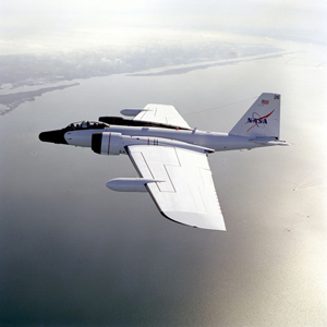
NASA also uses its WB-57 high-altitude (60-65 kft) aircraft during field campaigns. This plane has flight capabilities similar to the ER-2 but a shorter flight duration (approximately 6.5 hours). The WB-57 carries two crew members, which are positioned at separate tandem stations in the forward section of the plane. The pilot station contains all the essential equipment for flying the aircraft while the sensor operator station contains both navigational equipment and controls for the operation of the various instruments that are located throughout the aircraft. Unlike the DC-8 and ER-2 aircrafts, which are housed at NASA’s Dryden Flight Research Center in Edwards, CA, WB-57 aircraft are housed at NASA’s Johnson Space Center (JSC) in Houston, TX.
 NASA WB-57 aircraft. Image courtesy of NASA's Dryden Flight Research Center. |
|
During the 2010 Genesis and Rapid Intensification Processes (GRIP) campaign, NASA deployed its latest tool for scientific discovery, the unmanned Global Hawk. The Global Hawk is one of the largest unmanned airborne systems (UAS) and flies at altitudes of 55,000 to 65,000 ft. It has a range of 11,000 nautical miles and can fly for up to 30 hours at a time, three times the capability of a conventional aircraft. The Global Hawk was not built for flying in highly turbulent weather, however, so there was significant concern about flying it over a hurricane. Its maiden flight was over a dissipating Tropical Storm Frank (2010) in the eastern Pacific Ocean. At the time of the flight, the storm had cloud tops well below flight level. The first major test for the Global Hawk system was Category 4 Hurricane Earl (2010) in the western Atlantic Ocean. Since a WB-57 aircraft had reported no turbulence over Earl the previous day, the Global Hawk pilots readily positioned the unmanned aircraft over Earl and performed a flawless flight. During the remainder of GRIP, the Global Hawk also overflew the precursor to Hurricane Karl (2010), Hurricane Karl during rapid intensification, and Tropical Storm Matthew (2010).
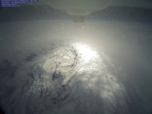 Imagery of Category 4 Hurricane Earl (2010), as taken by NASA’s Global Hawk unmanned airborne system (UAS). Image courtesy of NASA's Dryden Flight Research Center. |
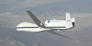 NASA’s Global Hawk unmanned airborne system (UAS). Image courtesy of NASA's Dryden Flight Research Center. |
In 2012-2014, NASA will use two Global Hawks in an investigation called the Hurricane and Severe Storm Sentinel (or HS3). One Global Hawk will carry instruments well suited for the environment, including a dropsonde system, a cloud physics lidar (for aerosol vertical profiles in Saharan air), a scanning infrared sounder, and a wind lidar. The second Global Hawk will be equipped to measure the inner-core structures of storms using a Doppler radar, microwave sounder, and microwave radiometer. Although the Global Hawk was deployed from Edwards Air Force Base in southern California during the 2010 GRIP campaign, the Global Hawks utilized in the 2012-2014 HS3 program will be based along the east coast at NASA’s Wallops Flight Facility in Virginia. This move was made in order to significantly increase the time over Atlantic storms. The GRIP and HS3 campaigns could pave the wave for more routine surveillance of hurricanes using Global Hawk by other agencies in the future.
References
|
|

