
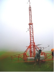
There are thousands of weather stations around the globe where observers report weather conditions every hour. The Coastal-Marine Automated Network (C-MAN) As mentioned in sections discussing observations made at sea, in addition to managing its network of buoys, the National Data Buoy Center (NDBC) has also established the Coastal-Marine Automated Network (C-MAN) to maintain meteorological observations in U.S. coastal regions. Approximately 60 stations around the U.S. coast, installed on lighthouses, at capes and beaches, on nearshore islands, and on offshore platforms, provide data on barometric pressure, wind direction, speed and gustiness, and air temperature. Some C-MAN stations are also designed to measure sea water temperature, water levels, waves, relative humidity, precipitation, and visibility. These data are processed and transmitted hourly to users via satellite communications. In addition to this conventional method of data transmission, certain C-MAN stations are equipped with telephone modems that allow more frequent data acquisition and data quality checking. Some U.S. coastal weather stations are now being designed to survive the extreme conditions associated with a landfalling hurricane. Such stations will improve data coverage along the U.S. coast, allowing forecasters and researchers to improve hurricane warnings. The Weatherflow Hurricane Network is a system of private company developed weather stations designed to survive winds of 225.3 km/h (140 mph). The stations collect high-resolution data for wind speed, wind direction, air temperature, and barometric pressure. When Hurricane Ike made landfall on the Texas coastline in September 2008, with wind gusts over 177 km/h (110 mph), all 7 WeatherFlow Hurricane Network stations in the Houston/Galveston, TX, region stayed online and collected data throughout the storm. These data were then relayed to National Hurricane Center (NHC) as well as local National Weather Service (NWS) Weather Forecast Offices (WFOs).
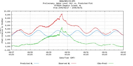
NOAA’s National Water Level Observation Network (NWLON) Before, during, and after a storm, NOAA monitors and disseminates observations of water levels, currents, and other information (winds, atmospheric pressure, air/water temperatures) in real-time. A part of NOAA’s Storm Surge Warning System, the National Water Level Observation Network (NWLON) is a significant source of water level data. It is a network of 175 long-term, continuously operating water-level stations throughout the United States. Stations are configured with water level sensors (and in some cases, other instruments) and provide real-time, automatic and event-driven data reports via the GOES satellite. Data collected helps coastal authorities prepare for, mitigate, and respond to storm tides and coastal flooding generated by severe storms.
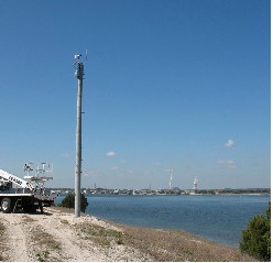
By virtue of their location along the coast, water level observing stations are often severely damaged by the storms for which they are collecting data. This often results in stations going off-line. NOAA Sentinel Towers are 25 ft tall observation structures strengthened to withstand wind and wave action associated with hurricanes up to Category 4 intensity on the Saffir-Simpson Hurricane Wind Scale. The sensor-packed stations are mounted on 4-ft diameter posts which are driven 60-80 ft into the seafloor to ensure stability. Four towers were installed in the Gulf Coast to replace other NWLON stations that were significantly damaged and/or destroyed by hurricanes in the mid to late 2000‘s. These hurricane-hardened stations ensure that continued, real-time meteorological observations are received at times critical to forecasting and evacuation planning. Mobile weather stations
|

 |
Please address comments and questions to hurricane@etal.uri.edu