
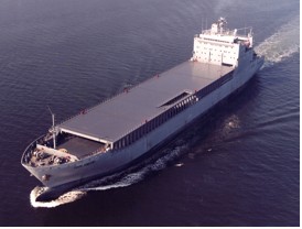
The oceans cover about two-thirds the surface of the earth, and for decades, ships were the only means of obtaining meteorological data from them. For centuries, people have sailed the world’s oceans and encountered storms. Before the invention of the wireless telegraph (two way radio) in 1905, reports of hurricane, typhoons, and tropical cyclones came weeks and months after a ship made port, usually at a remote port of call. 1909 marked the first time that a ship at sea in the midst of a hurricane was able to send a radio report back to the coast about the storm. Now, reports are routinely transmitted in real-time via radio and satellite outlets. Due to the importance of reports from the surface of the ocean, about 4,000 ships are currently participating in the World Meteorological Organization’s (WMO’s) international Voluntary Observing Ship (VOS) Program. The mission of the VOS project is two-fold: (1) to collect and disseminate real-time maritime weather observations and (2) to define the global climate and help measure extreme weather events, climate variability, and long-term climate changes. Crews are trained on how to take weather observations while at sea and also to calibrate weather sensors used aboard ships when they arrive in port, such as barometers and thermometers. The ships record and transmit meteorological observations such as air pressure, air temperature, sea surface temperature (SST), wind and sea state. The Beaufort scale is still occasionally used to determine wind speed from manual observers out at sea. Ships with anemometers, a device used for measuring wind speed, have difficulties accurately determining high wind speeds due to blockage of the instruments by high seas and the rolling of the ship. Observations are recorded by officers onboard (at the standard hours of 0000, 0600, 1200, and 1800 UTC) and are immediately sent to a meteorological station. In the past, VOS reports were actually transmitted in Morse code to coastal radio stations, but most reports are now relayed via satellite communication or by voice radio. Communication improvements have also led to enhancements in the quantity and quality of meteorological repots received from VOS.
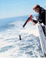
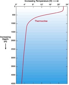
NOAA is actively participating in an international effort to increase the number of subsurface temperature observations in support of global oceanographic and climate studies. Many VOS ships deploy expendable bathythermographs (XBTs) to sample ocean temperature. The probe, which is dropped from a ship, measures temperature as it falls through the water. Two very small wires transmit the temperature data to the ship where it is recorded for later analysis. The probe is designed to fall at a known rate, so that the depth of the probe can be inferred from the time it was launched. Measuring the ocean’s temperature profile is important because a hurricane's intensity is affected not only by the initial sea surface temperature before the hurricane's arrival, but also by the amount the sea surface cools while the hurricane is overhead. The amount of sea surface cooling depends on the shape of the ocean temperature profile beneath the sea surface and how fast the hurricane is moving. (For information on how water temperature can influence a hurricane, please see Interaction between a Hurricane and the Ocean.)
Hurricane reconnaissance aircraft also drop probes, Airborne eXpendable BathyThermographs (AXBTs), to measure water column temperature. They function in much the same way, except they are launched from high altitude and communicate with the parent plane instead of a ship. Some may ask if ship-based observations are necessary with the existence of satellites. Observations from ships, including those participating in VOS, complement data collected by satellites as well as provide a long-term observational record for variables that cannot, as of yet, be consistently and accurately observed from space, such as surface air-pressure. Ships are also essential in the confirmation of satellite observations. Lastly, reports from ships continue to be routinely used in the preparation of weather forecasts, supplying a constant check on actual weather conditions and contributing directly to short-range predictions and weather models. |

 |
Please address comments and questions to hurricane@etal.uri.edu