
Hurricane Camille was the third and strongest tropical cyclone and second hurricane during the 1969 Atlantic hurricane season. It smashed into the Mississippi Gulf Coast on the night of August 17, 1969, and carved a path of destruction until the early hours of 18 August. The hurricane began as an inverted “V”-shaped tropical wave off the African coast on August 5, 1969. It moved west across the Atlantic Ocean without much organization until 13 August, when its convection convection increased. On 14 August, hurricane hunters hurricane hunters set off to investigate two possible circulation centers associated with the system. Later that day, they determined that Tropical Storm Camille had formed about 97 km (60 mi) west of Grand Cayman Island. As the storm moved in a northwesterly motion through the western Caribbean, conditions were supportive of strengthening, and a rapid drop in pressure occurred (42 mb in less than 24 hours). The tropical storm became a hurricane while located about 97 km (60 mi) south-southeast of Pinar del Rio, Cuba. By the afternoon of 15 August, just 12 hours after becoming a hurricane, Camille had intensified into a Category 3 hurricane with winds of 185 km/h (115 mph). Later that day, Hurricane Camille made landfall in far western Cuba somewhere between Guane and Cape San Antonio. The hurricane produced up to 255 mm (10 inches) of rain near Guane. Throughout Pinar del Río Province, Camille caused heavy damage, primarily from river flooding, and about 20,000 people were left homeless. Initially, the Cuban government reported no casualties from the storm, however subsequent research indicated the hurricane killed five people in the country, and damage was estimated at $5 million (1969 USD).
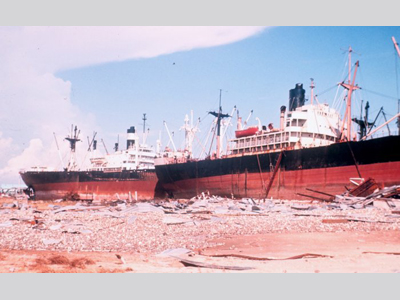
Due to the interaction with land as it crossed Cuba, Hurricane Camille weakened slightly as it reemerged into the Gulf of Mexico. At first, forecasters expected the hurricane to next strike the Florida panhandle. However, it instead continued on a northwesterly path, rapidly intensifying along its track. On 16 August, Hurricane Camille displayed winds of 241 km/h (150 mph). It further intensified the next day, showing winds of 257 km/h (160 mph) and a low pressure of 905 mb, making Camille the second most intense hurricane ever recorded in the Atlantic basin at that time, behind only the 1935 Labor Day Hurricane. As Hurricane Camille was located 161 km (100 mi) southeast of the Mississippi River Delta, its winds were 306 km/h (190 mph). On 18 August, Hurricane Camille made landfall on Mississippi between Bay St. Louis and Pass Christian as an incredibly powerful hurricane. The precise wind speed at landfall will never be known because all measuring instruments were destroyed during the hurricane’s impact (it is estimated that gusts reached 322 km/h [200 mph]). Electricity also went out as the storm approached. As Hurricane Camille came ashore, it caused a great amount of destruction. A 7.5 m (24.6 ft) storm surge inundated 860,000 acres of land in Louisiana and overtopped seawalls along the Mississippi shore, pushing water three to four blocks inland along the state’s entire coast. U.S. Highway 90, which runs along the shore, flooded as the storm surge crested seawalls and was badly broken and covered in much debris. The barrier islands along the Gulf Coast were badly damaged. The storm surge inundated 70% of Dauphin Island, a 22.5 km (14 mi) long island along the Alabama coast. A combination of strong winds and rain split Ship Island, off the coast of Mississippi, into two separate islands, and Louisiana’s Chandeleur Islands were also cut in many places. This type of destruction, called channel incision, is the most destructive hurricane impact on barrier islands. Hurricane Camille weakened quickly as it moved inland. It became a tropical storm within 12 hours of landfall and then a tropical depression before reaching the Tennessee border, where it began turning toward the north/northeast. More destruction occurred after the system moved eastward through Kentucky. It dumped a large amount of rain over West Virginia and Virginia on 19-20 August. The rainfall totals were generally between 300-510 mm (12-20 in) across the two states, with the highest amount in the mountains of southwestern Virginia with totals over 660 mm (26 in) – the highest amount ever recorded in this state from a tropical cyclone as of 2001. More than 133 bridges were wiped out in the mountain region of Nelson County, VA during the floods. Many communities were partially destroyed in Nelson and neighboring counties with 8,931 people injured, 5,662 homes destroyed, and 13,915 homes experiencing major damage. The flash floods and mudslides generated by Camille’s heavy rains caused $140 million (1969 USD) worth of damage in Virginia and took 153 lives. The remnants of the tropical depression moved close to Norfolk, VA, but then tracked back into the Atlantic Ocean where it was able to regain tropical storm status on 21 August. A cold front south of the Canadian Maritime Provinces absorbed the then extratropical system, on 22 August. In total, 19,577 homes received major damage or were completely destroyed, 257 people lost their lives, and a total of $1.42 billion (1969 USD) worth of damage occurred as a result of Hurricane Camille. Mississippi sustained the largest amounts of damage, with the total amounting to $950 million (1969 USD) and 50 deaths in the state. Fast Facts:
Sources:
Masters, Jeffrey. A Detailed View of the Storm Surge: Comparing Katrina to Camille. Wunderground. Web. Accessed 21 Dec. 2009. < http://www.wunderground.com/hurricane/surge_details.asp> Hurricane Camille. Wikipedia. 2009. Web. Hurricane Histories – Hurricane Camille. National Hurricane Center. Web. Simpson, R.H. et al. “The Atlantic Hurricane Season of 1969” National Hurricane Center, U.S. Weather Bureau. 1970. Web. Preliminary Report on Hurricane Camille. U.S. Department of Commerce, Environmental Science Services Administration, U.S. Weather Bureau. 1969. Pp. 1-3. Web. Virginia Hurricane Climatology. Hydrometeorological Prediction Center, National Weather Service. Updated July, 2001. Roth, David M. “Hurricane Camille.” National Weather Service Hydrometeorological Prediction Center. Web. Hobgood, Jay S. “A Comparison of Hurricanes Katrina (2005) and Camille (1969).” 27th Conference on Hurricanes and Tropical Meteorology. 28 Apr. 2006. Web. Morton, Robert et al. “Morphological Impacts of Hurricane Camille (1969) On Barrier Islands of Mississippi and Western Alabama.” U.S. Geological Survey. 2009. Web. Hearn, Philip D. Hurricane Camille: Monster Storm of the Gulf Coast. Jackson: The University Press of Mississippi, 2004. Roth, David. “Louisiana Hurricane History.” National Weather Service. 2010. Pp. 42. Web. Thirty Years After Camille US Army Engineer District, Mobile Alabama. Report on Hurricane Camille. http://www.csc.noaa.gov/hes/docs/postStorm/H_CAMILLE.pdf Howard, Judith. Category 5: The Story of Camille. Ann Arbor: University of Michigan Press, 2005. Images: The photographs of damage attributed to NOAA can be found here: “Camille on 16 August” “Camille Track 1” “Camille Track 2” “Comparison to Katrina” “Great Storms” “In the Gulf “ “Rainfall from Camille” “Scene of Destruction” “Storm Surge Graphic” |
 |
Please address comments and questions to hurricane@etal.uri.edu