
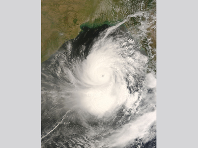
In May 2008, Myanmar (formerly known as Burma) experienced its greatest natural disaster, Cyclone Nargis. The tropical system, which would become Nargis developed from a low pressure system in the Bay of Bengal during the last week of April. Early on 27 April, the India Meteorological Department (IMD) declared the system had strengthened to a tropical depression about 748 km (465 mi) east-southeast of Madras, India. The depression slowly moved north-northwest at about 11 km/h (7 mph) as convective banding around its center increased. On 28 April, the system was centered 547 kilometers (340 miles) east of Madras and the IMD upgraded the storm to a cyclone, Nargis. This is the equivalent of a Category 1 hurricane on the Saffir-Simpson Hurricane Wind Scale [link to Section 2 Content]. Due to the presence of high pressure ridges to the northwest and southeast, the cyclone remained stationary over the warm Bay of Bengal on 28 April, allowing it to intensify further. By the morning of 29 April, the cyclone had winds of 161 km/h (100 mph), making it equivalent to a Category 2 hurricane or a very severe cyclonic storm, as regarded by the IMD. Later that day, drier air became entrained in the cyclone and, as a result, its convection decreased and the cyclone weakened. It began to move northeastward and was downgraded to a tropical storm.
On 1 May, Nargis began to rapidly intensify and track eastward, returning to cyclone status. By 2 May, the cyclone reached its peak status with winds of 217 km/h (135 mph) (equivalent to a Category 4 hurricane). At this intensity, Cyclone Nargis made landfall in southwest Myanmar on 2 May, near the town of Wagon in the Ayeyarwady Division. The storm moved inland, but remained along the coast of the Irrawaddy Delta, which prevented the rapid weakening traditionally exhibited by cyclones as they moved over land. Structural damage largest city and former capital, Yangon, winds were still 129 km/h (80 mph) (Category 1 strength). After turning to the northeast, and encountering rough terrain along Myanmar’s border with Thailand, the system dissipated on of 3 May. It is estimated that at least 2.4 million people were severely affected by this cyclone. Structural damage throughout Myanmar was extensive, causing over a million to become homeless after the event. In the first few days following the cyclone, as many as 260,000 people were living in camps throughout the Irrawaddy River Delta. The cyclone’s heavy rains and 3.6 m (12 ft) storm surge caused widespread flooding, destroying 90-95% of the buildings in the low-lying delta. Floodwaters penetrated an estimated 40-50 km (24-31 mi) inland from the coast. Farmland, livestock, and fisheries were all destroyed. Although the cyclone’s true death toll may never be known, well over 90,000 people were confirmed dead. In the southwestern town of Labutta, 80,000 people were killed. An additional 55,000 people were originally estimated to be missing, and to date having not been recovered (they are presumed dead). It is feared that between hundreds of thousands and a million people may have possibly lost their lives in this disaster, which is comparable to the death toll from the Indian Ocean tsunami in 2004. In all, over $10 billion (2008 USD) in damage was estimated as a result of the cyclone, making Nargis the costliest cyclone to have occurred in the North Indian Ocean basin. Notable for this cyclone was the local government’s resistance to international aid. The military Junta did not want foreign personnel, including relief workers, or their aid in the disaster area. On 8 May, the Myanmar government representation from the United States formally asked the United Nations (UN) for help; however the Myanmar government did not endorse international aid and placed harsh restrictions on even the most basic forms of assistance. It was not until 9 May, a full week after the cyclone made landfall, that the Junta finally gave into international pressure to accept outside aid. However, this aid was limited to food, medicine and basic supplies, and foreign aid workers remained banned from the country. International disapproval came harshly against the Myanmar government. With the possibility of 1.5 million facing death in the densely populated disaster area due to starvation, exposure, and disease, world leaders, including the then (and present day) UN Secretary General, Ban Ki-Moon, pleaded with the Junta to allow in additional assistance. Finally, on 19 May, Myanmar granted members of the Association of South-East Asian Nations admittance into the country to deliver aid. After negotiations between Ban and the Myanmar head of state, Than Shwe, it was declared on 23 May that other international aid workers would be let into the country - a full 3 weeks after the cyclone struck. Fast Facts:
Sources:
“Post-Nargis Joint Assessment.” Tripartite Core Group. July 2008. Web. NASA: Hurricane Season 2008: Tropical Storm Nargis (Indian Ocean) NASA Earth Observatory News. 2009. NASA Study Finds ‘Pre-Existing Condition’ Fueled Killer Cyclone. Webster, P.J. 2008. Myanmar’s deadly daffodil. Nature Geoscience. 488-490. “Cyclone Nargis.” Wikipedia. 2010. Web. “Tropical Cyclone 01B Warning NR 001.” Joint Typhoon Warning Center. 27 Apr. 2008. Web. “Cyclonic storm “NARGIS” over southwest and adjoining southeast and west central Bay of Bengal.” India Meterological Department. 28 Apr. 2008. Web. |
 |
Please address comments and questions to hurricane@etal.uri.edu