
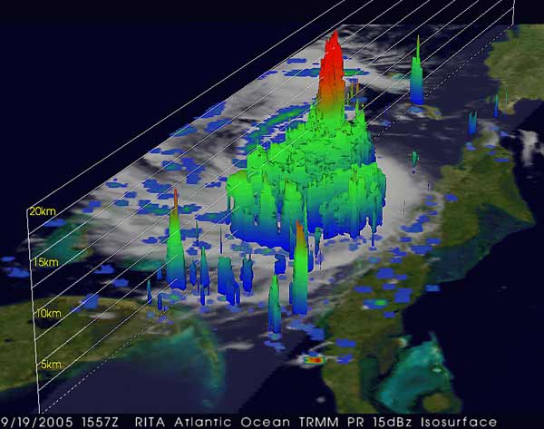
The Tropical Rainfall Measuring Mission (TRMM) satellite is a joint program between the National Aeronautics and Space Administration (NASA) and the Japan Aerospace Exploration Agency (JAXA). The TRMM satellite is in a low Earth orbit and covers the entire tropics and subtropics in about a day. The Tropical Rainfall Measuring Mission (TRMM) is the first mission to make rainfall measurements over the global tropics and subtropics. Before TRMM, the distribution of tropical rainfall was very uncertain, especially the variation throughout the day. The TRMM satellite is not in a sun-synchronous orbit - this allows it to measure precipitation at different times throughout the day and night. The TRMM satellite has a number of instruments, but three are particularly useful for tropical weather modeling and forecasting. TRMM has a Precipitation Radar instrument that can image storms in three dimensions up to a height of 20km (about 12 miles) from the Earth’s surface in a swath [insert km] 154 miles wide. This provides images of the rainfall patterns in a tropical cyclone, giving forecasters and researchers valuable data about the storm.
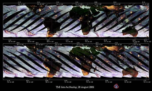
The second instrument on board TRMM is the Microwave Imager (TMI), which is a passive microwave instrument that provides quantitative rainfall information over a wide swath. The TMI has an 878km (547 miles) swath at the Earth’s surface. From the TMI, various measurements of rainfall are available, including monthly averages and rainfall anomalies.
A third instrument is the Lightning Imaging Sensor (LIS). The LIS detects and locates lightning over the tropical region of the globe. The lightning detector is a combination of optical and electronic elements capable of locating and detecting lightning within individual storms, day or night. Information about lightning can help forecasters understand the intensity of a storm.
|


 |
Please address comments and questions to hurricane@etal.uri.edu