During the second week of October 1998, a tropical wave moved through West Africa and off the coast on 10 October. This tropical wave would become the one of the deadliest and most costly hurricane’s ever seen in Central America, Hurricane Mitch. As the tropical wave moved through the tropical Atlantic Ocean after formation, upper-level winds prevented the system from strengthening. The system moved through the eastern Caribbean Sea on 18 and 19 October, where it finally became better organized. Thunderstorm activity began to increase and on 22 October and the system was classified as a tropical depression, located about 656 km (410 mi) south of Kingston, Jamaica. The storm moved in a small loop later that day, and while doing so, became Tropical Storm Mitch, the 13th named storm of the 1998 Atlantic Hurricane Season. On 24 October, the storm developed into a hurricane 469 km (293 mi) south-southwest of Kingston, Jamaica. After threatening Jamaica and the Cayman Islands, Hurricane Mitch took a turn for the west and rapidly intensified due to favorable conditions. The storm reached peak intensity on 26 October as a Category 5 hurricane displaying sustained winds of about 290 km/h (180 mph) and a low pressure of 905 mb – making it the lowest recorded pressure for any October hurricane ever recorded in the Atlantic at that time. On 27 October, the hurricane moved over the Swan Islands, an island chain located 145 km (90 mi) off the coast of Honduras. Weakening slightly due to its interaction with land, Hurricane Mitch meandered off the Honduran coast for a couple days, battering the island country (and the Swan Islands) with waves of 6.7 meters (22 ft) in height.
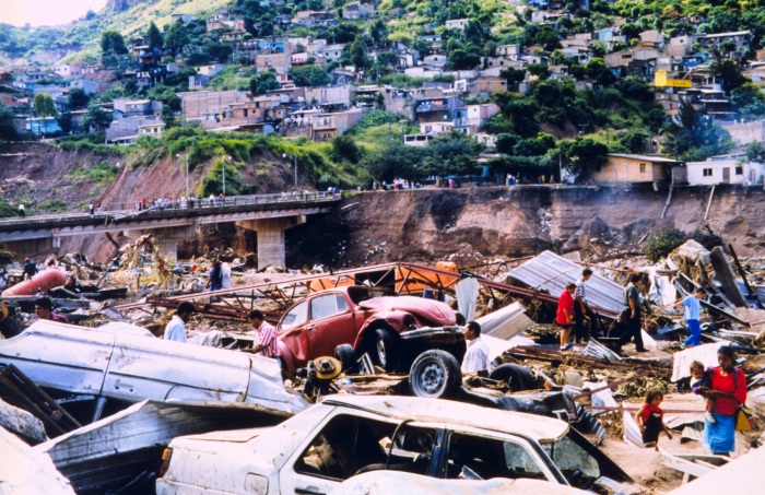
Early on 29 October the hurricane’s center made landfall 130 km (81 mi) east of La Ceiba, Honduras, as a weakened hurricane with winds of 158 km/h (98 mph) and an associated storm surge of 3.6 meters (12 ft). For the next week, the system moved very slowly through Honduras, Nicaragua, Guatemala, Belize, and El Salvador. The hurricane’s slow speed, about 7.4 km/h (4.6 mph), and its movement over the Cordillera Isabelia mountain range caused a tremendous amount of rain to fall in Honduras and Nicaragua. Rainfall totals amounted to over 912 mm (35.9 in) in Choluteca, Honduras, with other parts of the country receiving accumulations of over 250 mm (10 in). Hurricane Mitch weakened to a tropical storm on the morning of 20 October, and then to a tropical depression by the evening of 31 October. Mitch’s surface circulation disspiated near the Honduras-Guatemala border on 1 November, and its remnants moved off the Mexican coast into the Bay of Campeche on 2 November as a cloud-system center. Here, Mitch lingered as it regained tropical storm status, but as it made another landfall over the northwestern coast of Mexico’s Yucatan peninsula on 4 November, it weakened to a tropical depression. Re-emerging into the Gulf of Mexico later that day, the storm once again strengthened into a tropical storm. It accelerated through the Gulf of Mexico and made a final landfall near Naples, FL the on the morning of 5 November, with winds of 101 km/h (63 mph). The storm became extratropical later that day, and raced across the Atlantic Ocean as an extratropical cyclone until it dissolved north of Great Britain on 9 November. Hurricane Mitch produced incredible rainfall, which caused widespread flooding and generated many landslides, predominantly in Honduras and Nicaragua. No final international death toll has been established due to the extensive damage, but at least 11,000 people were killed and 9,191 more were missing. Flash floods and mudslides associated with Mitch’s rainfall destroyed tens of thousands of homes, rendering over 20% of Honduras’s population homeless. The majority of bridges and secondary roads in Honduras were heavily damaged or destroyed, causing many communities to become isolated and unable to receive assistance. The magnitude of the damage was so great that it is said that existing road maps were rendered useless. Flooding from Mitch also destroyed 70% of total crops in Honduras, including 80% of banana, 60% of sugar cane, and 58% of the corn crops. Crop damage itself amounted to losses of up to $1.7 billion (1998 USD). The other country receiving the brunt of Hurricane Mitch’s elements was Nicaragua, which, while damage was less severe than in Honduras, significant desctruction did occur. For example, a mudslide moving off La Casitas Volcano in the northeastern part of the country engulfed several communities at its base, amounting to a death toll of at least 2,000. As many as 23,900 homes were destroyed in Nicaragua along with 340 schools, and about 750,000 people lost their homes or possessions with half a million houses damaged. Many thousands of homes and a great number of crops and livestock were destroyed throughout the rest of Central America as well. 126 bridges and 1300 km (800 mi) of road were affected by mudslides and floods in Costa Rica, mostly along the Inter-American Highway that had been damaged by Hurricane Cesear two years prior. Damage in the United States was $40 million (1998 USD), due to the destruction of 645 homes in Florida caused by tornadoes. Total damage from the storm amounted to $5 billion (1998 USD). Fast Facts:
|


