
During the second week of October 2005, in the midst of the busiest Atlantic hurricane season in recorded history, a tropical disturbance forming southwest of Jamaica would become the most powerful hurricane ever documented in the Atlantic Basin. Hurricane Wilma had a complex beginning, and would go on to inflict extensive damage. The initially ill-defined system organized into a tropical depression on 15 October. At first, the depression moved erratically and slowly in the waters between Jamaica and Central America. The depression strengthened into a tropical storm on 17 October. The next day, Tropical Storm Wilma turned west-northwest and strengthened into a hurricane. The system then explosively intensified into a Category 5 hurricane with winds of 278 km/h (173 mph) in a span of just 24 hours. It continued to strengthen, and on 19 October, Hurricane Wilma broke the record books when it reached its peak intensity- the hurricane’s minimum central pressure dropped to 882 mb (hPa), the lowest pressure ever measured in an Atlantic hurricane (as of the beginning of the 2010 hurricane season).
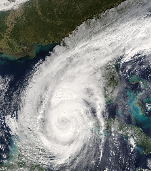
Hurricane Wilma weakened slightly, to a Category 4 storm, as it approached the coast of Mexico’s Yucatán Peninsula. On 21 October, the hurricane made landfall on the island of Cozumel with winds of 241 km/h (150 mph). In addition to strong winds, the storm also brought torrential rains and a large storm surge to the to the Yucatan Peninsula. In the town of Islas Mujeres, about 13 km (8 mi) northeast of Cancún, over 1575 mm (62 in) of rainfall was recorded. Significant flooding occurred throughout the Yucatan Peninsula, stranding hundreds of tourists in popular Mexican resort destinations. Property damage was very high in the hotel sector of Cancún, with estimates indicating $1.5 billion in losses. Mexico’s agriculture industry was also severely impacted by Hurricane Wilma. Agricultural losses totaled $4.6 billion (2005 USD) with total damages in Mexico at $7.5 billion (2005 USD). On 23 October, Hurricane Wilma moved off the northeastern Yucatan Peninsula as a Category 2 hurricane with winds of 158 km/h (98 mph). After emerging into the Gulf of Mexico, the storm accelerated towards Florida guided by a strong steering current. Over the open, warm waters of the Gulf, Hurricane Wilma again strengthened to a Category 3 Hurricane, with winds reaching 204 km/h (127 mph). On 24 October, the storm made another landfall near Cape Romano in southwestern Florida as a Category 3 hurricane. The hurricane moved very quickly, crossing the Florida Peninsula in just 4 ½ hours. Hurricane Wilma was able to strengthen once more upon reaching the Atlantic Ocean and was a Category 3 hurricane around midnight on 25 October. The hurricane moved quickly toward the northeast with no other landfalls and lost its tropical characteristics by the time it moved past Nova Scotia, Canada, on 26 October. Hurricane Wilma impacted southeast Florida, including the Florida Keys, with a 1.5-m (5-ft) storm surge. Due to the limited amount of time that the storm was over Florida, damage from flooding and high winds was greatly limited to infrastructure. Approximately 6,000,000 people in Florida lost electricity due to Wilma with most regaining service after 8-15 days. A combination of infrastructure damage, flooding, damage to sugar cane and citrus crops and other insured losses brought the total damage in Florida to over $20 billion, making Hurricane Wilma among the five costliest storms in United States history. The deaths of 23 people can be directly attributed to Hurricane Wilma, half of which occurred in Haiti due to mudslides and at least 6 occurring in Florida. Overall damages totaled to $29 billion with the US and Mexico reporting losses of $20.6 billion and $7.5 billion, respectively, and Cuba reporting $700 Million (all figures 2005 USD). Fast Facts:
|
 |
Please address comments and questions to hurricane@etal.uri.edu