Basic Statistics
Dates
Maximum wind speed Minimum pressure Deaths Damage Landfall
September 7-19, 1999
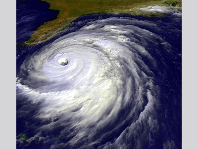
250 km/hr (155 mph) 921 mb 57 4.5 Billion U.S. The Bahamas, North Carolina Early, on September 16, 1999, Hurricane Floyd made landfall in Cape Fear, North Carolina. It was the second hurricane to have hit the state in less than one month, with Hurricane Dennis arriving just 10 days earlier. Floyd was first tracked as a tropical wave off western Africa on 2 September. The wave then moved westward across the Atlantic, undergoing no significant changes until 6 September when a curved band of deep convection developed. The following day the wave was upgraded to a tropical depression about 160 km (100 mi) east of the Lesser Antilles. On 8 September, the depression became Tropical Storm Floyd, and by 10 September, about 320 km (200 mi) east-northeast of the northern Leeward Islands, the system had reached hurricane strength. Floyd’s forward speed then slowed and its track shifted to the northwest. The storm headed toward the Central Bahamas, before it turned to the west-northwest on 13 September. This turn was followed by a period of rapid intensification: in 24 hours maximum sustained winds increased from 180 km/h (110 mph) to 249 km/h (155 mph), while the pressure dropped to 921 mbar (hPa). One contributor to the storm’s rapid intensification was the high oceanic heat content along the storm's path.
Hurricane Floyd remained just below Category 5 status on the Saffir-Simpson Hurricane Wind Scale for 12 hours while crossing the Bahamas, making landfalls on Eleuthera and Abaco islands on 14 September. An eyewall replacement cycle then weakened Floyd to a Category 3 hurricane with winds of 190 km/h (120 mph). By 15 September, Hurricane Floyd was parallel to the Florida coastline, passing just 152 kilometers (95 miles) east of Cape Canaveral on the eastern Florida coast. Here, the hurricane steadily weakened due to the entrainment of dry air and upper-level wind shear. Early on the morning of 16 September, Hurricane Floyd made landfall near Cape Fear, NC as a Category 2 hurricane moving at 27.8 km/h (17.3 mph) with winds estimated at 166 km/h (103.7 mph). Pushed along by a low-pressure front moving across the U.S. from the southwest, Hurricane Floyd quickly passed through the state. By late morning on 16 September, Floyd’s eye passed over eastern North Carolina and then over Norfolk, VA. After crossing over North Carolina and southeastern Virginia, Floyd briefly re-entered the western Atlantic Ocean before reaching Long Island on the 17 of September as a tropical storm. The storm gradually became extratropical over southern Maine late on the 17th. The extratropical cyclone continued to the northeast, and after passing over the Canadian Maritimes, it was absorbed by a cold front to the east of Newfoundland. Hurricane Floyd caused a disastrous flood event in the eastern United States, particularly in North Carolina. In total, eastern North Carolina received between 381-508 millimeters (15-20 inches) of rain, with Wilmington, NC reportedly receiving 483 millimeters (19 inches) throughout the duration of the storm, including a record 381 millimeters (15 inches) in a 24-hour period. These cumulative levels of rainfall put 14 regions in North Carolina at their 500-year flood levels. Parts of Florida received 229 millimeters (9 inches), while Maryland, Delaware, and New Jersey each reported 305- 356 millimeters (12-14 inches) of total rainfall. Philadelphia, Pennsylvania experienced a record rainfall of 173 millimeters (6.8 inches) in a single day as a result of Tropical Storm Floyd and over 1,000 residents were evacuated while 3,500 homes flooded. In total, between the U.S. and the Bahamas, Hurricane Floyd is estimated to have caused between $4.5 billion (1999 USD) in damages, with $1.6 billion (1999 USD) reported damages in Pitt County, NC where the peak flood level was observed. As a result of Hurricane Floyd, 57 fatalities were recorded across 8 states and the Bahamas. A majority of these deaths were due to inland flooding. The storm was considered to have been the deadliest since Hurricane Agnes, which struck the eastern Atlantic seaboard as a Category 1 hurricane in 1972 claiming 122 lives. Fast Facts:
Sources: Annual Summary: Atlantic Hurricane Season of 1999 Monthly Weather Review. 129: 3057- 3084 http://www.aoml.noaa.gov/general/lib/lib1/nhclib/mwreviews/1999.pdf Preliminary Report National Weather Service (NWS), Hydrometerological Prediction Center. Hurricane Floyd- September 14-17, 1999: NASA’s Earth Observatory: Hurricane Floyd Series Wikipedia-Hurricane Floyd: Hurricane Floyd Flooding in NC NOAA/NWS, Service Assessment Summary- Hurricane Floyd Floods of September 1999 Hurricane History- Hurricane Agnes NASA Earth Observatory: “The Ones That Got Away (Almost)” |


