
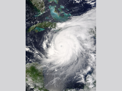
Hurricane Ivan was a Cape Verde-type hurricane type hurricane that originated from a tropical wave moving off the west coast of Africa on August 31, 2004. Favorable conditions allowed the system to develop deep convection and become a tropical depression on 2 September. Only twelve hours later, the depression was upgraded to a tropical storm. Tropical Storm Ivan moved westward over the next few days steadily strengthening as it did so. It became Hurricane Ivan on 5 September while located 1600 kilometers (1000 miles) east of Tobago. The hurricane intensified rapidly, reaching Category 3 intensity with 201 km/h (125 mph) winds later on 5 September. On 6 September Hurricane Ivan weakened, only to regain is former Category 3 strength with winds of at least 185 km/h (115 mph) by the time that it passed 10 km (6 mi) south-southwest of Grenada on 7 September. After battering several of the Windward Islands, Hurricane Ivan entered the Caribbean Sea and continued to intensify. On 9 September, while located just north of the Netherlands Antilles, the hurricane had winds of 257 km/h (160 mph), attaining Category 5 status for the first time (Ivan would go on to weaken and intensify to Category 5 status two more times).
Continuing west-northwest, the hurricane’s center passed 32 kilometers (20 miles) south of Jamaica on 11 September. At this point, the hurricane had weakened to Category 4 strength, most likely as a result of an eyewall replacement cycle. This, combined with a westward turn in forward motion, kept the center of the hurricane at least 37 km (23 mi) offshore of Jamaica, though the island still experienced hurricane force winds. After affecting Jamaica, the hurricane resumed its west-northwestward track and regained Category 5 status, though only for six hours, after which it was downgraded to a Category 4 hurricane. On 12 September, Hurricane Ivan re-strengthened to reach its peak intensity with 274 km/h (170 mph) winds and a low pressure of 910 mbar while located 129 km (80 mi) west of Grand Cayman as a Category 5 hurricane. At the time, this made Hurricane Ivan the 6th most intense Atlantic hurricane on record. As it passed Grand Cayman, the hurricane caused a 3 m (10 ft) storm surge to nearly inundate the entire island. Hurricane Ivan passed by the extreme western tip of Cuba on 13 September as a Category 5 hurricane, but again weakened to Category 4 strength once it entered the Gulf of Mexico. Wind shear and cooler waters caused Hurricane Ivan to further weaken before making its first U.S. landfall. On the morning of 16 September, the hurricane made landfall near Gulf Shores, AL, on the Alabama-Florida border, as a Category 3 hurricane with winds of 193 km/h (120 mph) and a 4.3-m (14-ft) storm surge. It weakened rapidly over land, becoming a tropical depression later that day. Although the system was a weak tropical depression, it continued to produce exceptional amounts of rain and tornadoes over the southeastern United States. The system temporarily lost tropical characteristics while moving over Virginia on 18 September. The remnants then moved in an offshore loop before crossing over southern Florida on 21 September and moving into the Gulf of Mexico later that day. A remnant low began to redevelop over the warm waters of the Gulf, and after some debate, it was determined that the system had redeveloped into a tropical storm 193 kilometers (120 miles) south of the Mississippi River Delta on 22 September. Surprisingly, the system reacquired the name Tropical Storm Ivan five days after its first U.S. landfall. After taking a turn for the northwest and weakening some, Ivan made its final landfall late on 23 September in southwestern Louisiana as a tropical depression before dissipating at last over Texas on 24 September. Hurricane Ivan killed 39 people as it passed over Grenada, the worst the island has seen since Hurricane Janet (1955). Elsewhere in the Caribbean, hundreds of homes were destroyed and over $47 million (2004 USD) in damages occurred. In Jamaica, floods and wind left 18,000 people homeless and most of the public utilities were damaged. The Cayman Islands were hit especially hard as the at-peak Category 5 hurricane had passed close by and 95% of structures on the islands were damaged, with 25% of them left uninhabitable. For several months, the residents of Grand Cayman were without power, water, or sewer services. A large amount of damage occurred as the Category 3 hurricane came ashore in the United States. In Alabama, where the eye came ashore, damage was extensive. A powerful 4.3-m (14-ft) storm surge destroyed many buildings, including two 5-story condominium buildings made of steel-reinforced concrete. Communities 80 km (50 mi) inland, such as Brewton, AL, saw severe damage leaving some residents without power for up to 14 days and closing stores for up to a week. Pensacola, FL and areas west were the hardest hit, however. Having taken the brunt of the storm, all structures on Perdido Key, off of Pensacola, were almost completely destroyed. A 400 m (0.25 mi) section of the Interstate 10 Bridge across Escambia Bay collapsed into the water during the storm, and roads near Pensacola beach were devastated from the storm surge, with some roads near Pensacola Beach remaining closed through the end of 2007. Rainfall from the system caused rivers along the entire U.S. eastern seaboard to swell. The Delaware River rose to levels just below their record crests of 11.8 m (38.9 ft) set by the rains of Hurricane Diane in 1955. In North Carolina, areas recently flooded by Hurricane Frances were again flooded by the remnants of Hurricane Ivan. Near Franklin, NC, a debris flow of mud, rocks, water, and trees moved quickly down a creek as a result of the rain and swept away 15 houses, killing 5 people as it did so. The system also spawned over 115 tornadoes across affected areas in the United States. In Virginia, 40 tornadoes touched down in one day, which was a record for that state; no fatalities occurred. Hurricane Ivan proved to be among the most costly hurricanes in U.S. history with and estimated $13 billion (2004 USD) in damages. At the time, it ranked third costliest, but was displaced to 6th after hurricanes Katrina (2005), Wilma (2005) and Ike (2008) impacted the United States. In total, Hurricane Ivan was directly responsible for 91 deaths and about $18 billion (2004 USD) in damage along its track. Fast Facts:
Sources:
Franklin, James L. et al. “Annual Summary: Atlantic Hurricane Season of 2004.” Monthly Weather Review 134 (2006). Pp. 995-1002. Web. “Hurricane Ivan.” Wikipedia. 2009. Web. Stuart, Stacy R. “Topical Cyclone Report: Hurricane Ivan 2-24 September 2004.” National Hurricane Center. 2005. Web. Wang, David W. et al. “Extreme Waves Under Hurricane Ivan.” Science 309.5736 (2005). Pp. 836. Web. Emanuel, Kerry A. Divine Wind. Oxford: Oxford University Press, 2005. Pp. 260. Sallenger, A.H., Stockdon, H.F., Fauver, L., Hansen, M., Thompson, D., Wright, C.W., and Lillcrop, J. 2006. Hurricanes 2004: An Overview of Their Characteristics and Coastal Change. Estuaries and Coasts. 29 (6A): 880–888. |
 |
Please address comments and questions to hurricane@etal.uri.edu